
Gr IX Geography: The Balochistan Plateau
Presentation
•
Geography
•
9th - 10th Grade
•
Practice Problem
•
Hard

Jamshid Minwalla
Used 21+ times
FREE Resource
15 Slides • 0 Questions
1
Gr IX Geography: The Balochistan Plateau
The vast tableland of Balochistan contains a great variety of physical features.

2
The Baluchistan Plateau: Location
Located in the south-west of Pakistan with altitudes rabging from 600-3010 metres.
The area covers 347,190 sq km with a number of distinct natural topographical and drainage features.

3
Basins of Northern Baluchistan
Irregular depressions such as Zhob and Loralai basins which are situated between the Toba Kakar Ranges and the Sulaiman Range
The Quetta valley lies south-west of the Loralai basin.
Rainfall is infrequent but when it does rain, the rivers transport and deposit gravel, boulders sand and silt to form alluvial fans on the piedmont plains

4
What is an alluvial fan?
An alluvial fan is a triangle-shaped deposit of gravel, sand, and even smaller pieces of sediment, such as silt. This sediment is called alluvium.
Alluvial fans are usually created as flowing water interacts with mountains, hills, or the steep walls of canyons.
Streams carrying alluvium can be trickles of rainwater, a fast-moving creek, a powerful river, or even runoff from agriculture or industry.

5
Basins of Western Balochistan
There are a number of basins between mountain ranges such as Chagai Hills, Ras Koh, Siahan and Central Makran
The area is totally devoid of vagetation due to infrequent rainfall

6
Characteristics of Basins
These basins have no outlet to the sea
When it does rain, the rain is capyured into these basins.
The water soaks into the ground or gathers in temporary lakes.
These basins are called inland drainage basins.
They are salt lakes; when water evaporates; leaving a salty crust known as a salt pan

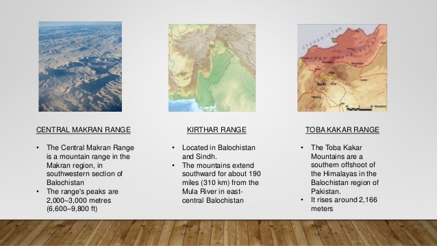
7
Mountain Ranges within the Balochistan Plateau
Ras koh (3010 m)
Kirthar Range
Central Brahui Range
Toba Kakar Range
Central Makran Range (900-1200 m)
Makran Coastal Range (600 m)
8
Balochistan's Economic Potential
Surrounded and crossed by mountains
To the south is a narrow coastal plain bordering the Arabian Sea
The area has low rainfall so the climate is dry
There is no major source of water for either drinking or irrigation
Absence of link roads
Limited railway line coverage

9
Economic Structure
Crop farming and livestock are the main pursuits of the people in Balochistan
About 67% of the labor force is involved in agriculture
It is a poor province - annual per capita is PKR 455
Insufficient rain and poor irrigation is a problem for formers

10
Economic Wealth of Balochistan - Mineral Resources
The area is rich in gold, silver, platinum, urnanium, antimony. crude oil and natural gas. About 46% of the nation's natural gas comes from Sui.

11
Economic Wealth of Balochistan - Fruit Production
The main fruits are: dates, grapes, apples, almonds, apricots, plums, peaches, melons and pomergranates. There is a surplus -- how can this be potentially advantageous?

12
Economic Wealth of Balochistan -Vegetable Seed Production
The uplands have cooler temperatures (cold winters) -- good for transplantation of seeds. Warm and dry summers are excellent for superior and extensive flowering and formation of high quality seeds.

13
Economic Wealth of Balochistan -Livestock and their Products
Nomadic farming-- due to scarcitry of rainfall and irrigation. Wool, goat hair and skins are important livestick products. These products have to go through a gradng process to ensure high quality -- for exporting.

14
Economic Wealth of Balochistan - Fishing (Subsistence and Commercial)
Gawdar: 10,000 tonnes of fish and 200 tonnes of shrimp annually -- exported to Sri Lanka
Pasni: 2,500 tonnes of fish -- 400 tonnes consumed locally -- balance exported to Sri Lanka
Ormara: 700 tonnes annually -- exported to Sri Lanka

15
Balochistan Plateau
Balochistan is a province that is rich in resources but remains the second poorest in the nation. If you were the Governor of Balochistan, what would you do to enhance the economic potential of your province? (See pg 16 of text)

Gr IX Geography: The Balochistan Plateau
The vast tableland of Balochistan contains a great variety of physical features.
Show answer
Auto Play
Slide 1 / 15
SLIDE
