
1.2.2 Map Scale
Presentation
•
Social Studies, Geography
•
6th Grade
•
Practice Problem
•
Medium
Katelyn Helus
Used 146+ times
FREE Resource
8 Slides • 6 Questions
1
Lesson 1.2.2
Map Scale
2
Main Idea
Maps use different scales for different purposes.
3
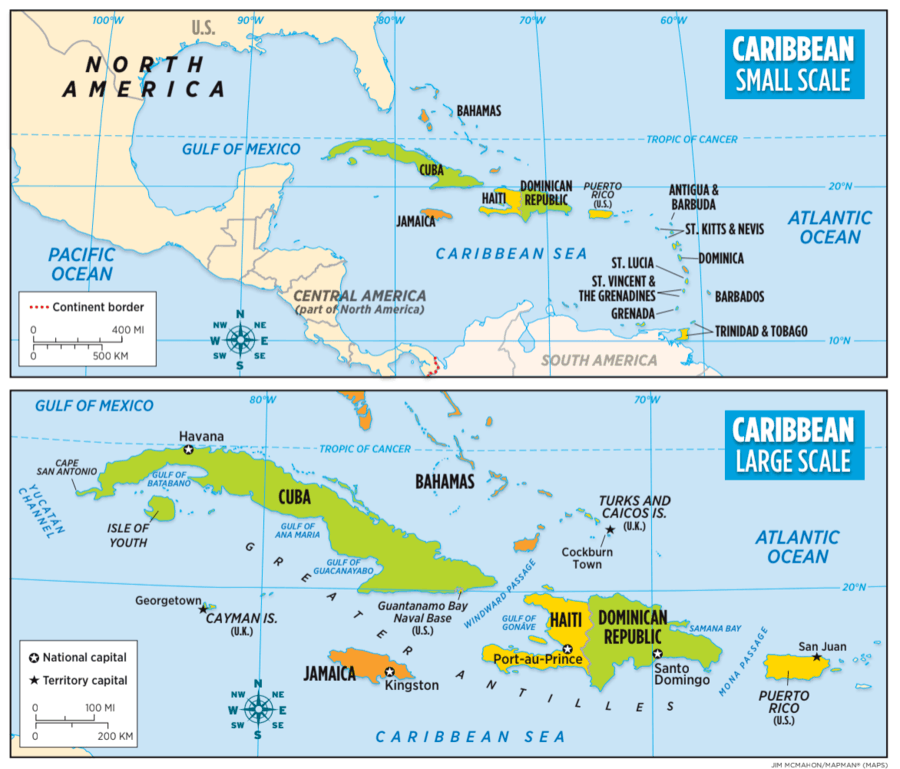
Maps have different scales
map scale shows how much distance on Earth is shown on the map
large-scale maps cover a small area but shows many details
small-scale maps cover a large area but includes few details
4
Scales are shown on ALL maps!
a scale is usually shown in inches
one inch on the map represents a much
larger distance on Earth, such as a number of miles
the scale of a map should be appropriate for its purpose
For example, a tourist map of Washington D.C. should be large-scale, showing every street name, monument, and museum.
Maps of any scale also show geographic patterns
The map of Washington D.C. , for example, would show that many government buildings are in one area in that city
5
6
Think of the map you just looked at..
That map is a small-scale map. The countries look small because the map is showing a big area. Small-scale maps are useful for showing vast regions, such as entire continents or many countries. This small-scale map shows all 13 independent countries in the Caribbean, plus the U.S. territory of Puerto Rico. This allows you to see their location in relation to North America and South America.
7
8
Think of the map you just looked at..
That map is a large-scale map. The countries appear larger and in greater detail because a much more limited area is shown. Large-scale maps are useful for showing a lot of detail, such as national capitals and cities, and even streets, parks, and other features of a single neighborhood or community. The large-scale map zooms in on a group of islands known as the Greater Antilles (an-TIH-leez). The Greater Antilles include Cuba, the Cayman Islands, Jamaica, Haiti, the Dominican Republic, and Puerto Rico. The eight smaller Caribbean nations that lie east of the Greater Antilles are known as the Lesser Antilles. The islands on this map appear large, making it possible to include more information, such as the location of capital cities and various bodies of water.
9
Multiple Choice
Which map allows you to see a place in greater detail? Use the image to help you.
Large Scale
Small Scale
10
Multiple Choice
Which map allows you to see a greater area? Use the image to help you.
Large Scale
Small Scale
11
Multiple Choice
Which type of scale map would you use to indicate the location of all the countries on a continent? Use the image to help you.
Large Scale
Small Scale
12
Multiple Choice
Which type of scale map would you use to help a driver get from one side of a city to the other? Use the image to help you.
Large Scale
Small Scale
13
Multiple Choice
Which map’s scale measures a greater distance between tick marks? Use the image to help you.
Large Scale
Small Scale
14
Open Ended
Summary Question:
What are the purposes of small-scale maps and large-scale maps?
Lesson 1.2.2
Map Scale
Show answer
Auto Play
Slide 1 / 14
SLIDE
Similar Resources on Wayground
10 questions
Washington precedents
Presentation
•
7th Grade
10 questions
Articles of Confederation
Presentation
•
7th Grade
13 questions
Colonization of Australia
Presentation
•
6th Grade
11 questions
Globalization Lesson
Presentation
•
6th Grade
13 questions
US/Canada Types Of Governments
Presentation
•
6th Grade
13 questions
The Rise of the Incan Empire
Presentation
•
6th Grade
12 questions
Maps and Regions
Presentation
•
6th Grade
10 questions
Chapter 9 Vocabulary
Presentation
•
6th Grade
Popular Resources on Wayground
20 questions
STAAR Review Quiz #3
Quiz
•
8th Grade
20 questions
Equivalent Fractions
Quiz
•
3rd Grade
6 questions
Marshmallow Farm Quiz
Quiz
•
2nd - 5th Grade
20 questions
Main Idea and Details
Quiz
•
5th Grade
20 questions
Context Clues
Quiz
•
6th Grade
20 questions
Inferences
Quiz
•
4th Grade
19 questions
Classifying Quadrilaterals
Quiz
•
3rd Grade
12 questions
What makes Nebraska's government unique?
Quiz
•
4th - 5th Grade
Discover more resources for Social Studies
15 questions
Civil War Effects on Texas Review
Quiz
•
6th - 8th Grade
19 questions
Asia- Culture
Quiz
•
6th Grade
15 questions
Review- U.S. & World
Quiz
•
6th - 8th Grade
14 questions
Asian Governments & Economics Review
Quiz
•
6th - 8th Grade
16 questions
Geography of Australia
Presentation
•
6th Grade
11 questions
Flour, Lumber & Mining Pre-test
Quiz
•
6th Grade
20 questions
Canada Unit Test
Quiz
•
6th Grade
33 questions
6.1-6.3 Geography Test
Quiz
•
6th Grade