Search Header Logo
Topographic maps

Topographic maps

Assessment

Presentation

Science

8th Grade

Practice Problem

Medium

NGSS
MS-ESS2-2, MS-ESS2-3, 4-ESS2-2

+4

Standards-aligned

Created by

Negron-Arocho Miguel

Used 9+ times

FREE Resource

12 Slides • 39 Questions

1

Topographic maps

Slide image

2

Slide image

3

Slide image

4

Slide image

5

Slide image

6

Slide image

7

Slide image

8

Slide image

9

Slide image

10

Slide image

11

Slide image

12

Slide image

13

Multiple Choice

Question image
What is the most likely elevation of the mountain peak? (Contour interval is 100 m)
1
1550  meters
2
 1652 meters
3
1500 meters
4
1700 meters

14

Multiple Choice

The youngest rocks on the seafloor are most likely found...
1
closest to a mid-ocean ridge
2
farthest from a mid-ocean ridge
3
near the coastlines
4
closest to a deep sea trench

15

Multiple Choice

The Great Rift Valley in Africa and the Mid-Atlantic Ridge were both created by this type of plate boundary. 
1
divergent
2
convergent
3
transform
4
subduction

16

Multiple Choice

Question image
How many mountain peaks are represented?
1
one
2
two
3
three
4
four

17

Multiple Choice

Question image
How many mountain tops does this map have?
1
one
2
two
3
three
4
four

18

Multiple Choice

Question image
What do close contour lines represent on a map?
1
waterfall
2
steep area
3
gradual area
4
river

19

Multiple Choice

What is the elevation at sea level?
1
0
2
100m
3
20m
4
3000m

20

Multiple Choice

Question image
What is the elevation of point B? (Contour interval is 100m)
1
800 ft
2
850 ft
3
900 ft
4
1000 ft

21

Multiple Choice

Question image
What is the profile view to Topographic Map #2?
1
B
2
C
3
D
4
E

22

Multiple Choice

Question image

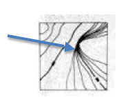
What is the profile view to Topographic Map #1?

1

A

2

B

3

C

4

D

23

Multiple Choice

Question image

Match topographic map #3 with the appropriate profile.

1

A

2

B

3

C

4

D

24

Multiple Choice

Question image

Match topographic map #4 with the appropriate profile.

1

C

2

D

3

E

4

F

25

Multiple Choice

Question image

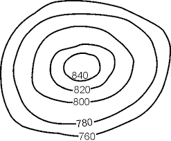
Which side is steeper?

1

The left side of the hill

2

The right side of the hill

26

Multiple Choice

Question image
Provided is a topographic map of a hill with contour lines drawn showing elevation in meters.
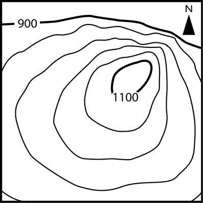
The steepest slope on this hill can be found on the side that is facing which direction?
1
Southwest
2
Northeast
3
Northwest
4
Southeast

27

Multiple Choice

Question image
What are the darker lines called?
1
roads
2
index contour
3
contour interval
4
waves

28

Multiple Choice

Question image
Determine the contour interval:
1
5 m
2
10 m
3
15 m
4
20 m

29

Multiple Choice

Question image
What feature is at the arrow?
1
volcano
2
mountain
3
cliff
4
river

30

Multiple Choice

Question image
What is the contour interval on this map?
1
100
2
10
3
15
4
20

31

Multiple Choice

Question image
What is the highest elevation this hill could possibly have? (might not be labeled)
1
1040
2
1060
3
1079
4
1009

32

Multiple Choice

Question image
Which topographic map matches formation C?
1
1
2
2
3
3
4
4

33

Multiple Choice

Question image
Which side of Holland Hill is the steepest?
1
North
2
South
3
East 
4
West

34

Multiple Choice

Question image
What is the elevation of the peak of the small island on the left side?
1
About 20 meters
2
About 40 meters
3
About 60 meters
4
About 200 meters

35

Multiple Choice

Question image
In which direction is Mill River flowing?
1
Southeast
2
Southwest
3
Northeast
4
Northwest

36

Multiple Choice

When you move from one contour line to another, the elevation
1
stays the same
2
goes up or down
3
disappears
4
is below sea level

37

Multiple Choice

If contour lines are close together, then the slope is
1
gentle
2
steep
3
flat
4
going up and down

38

Multiple Choice

This layer is divided into pieces called tectonic plates.
1
Mesosphere
2
Asthenosphere
3
Mantle
4
Lithosphere

39

Multiple Choice

What geologic feature/event would you most likely to find at a divergent boundary between two pieces of oceanic crust?
1
Rift Valley
2
Mid-Ocean Ridge
3
Island Arc
4
Flat land

40

Multiple Choice

Which answer below correctly describes the formation of a volcanic island arc?

1

Islands are created along the mid ocean ridge as new oceanic crust is formed.

2

Islands are created one at a time as the plate moves across a hot spot in the mantle.

3

Islands are created along a subduction zone as oceanic crust is forced back down in to the mantle.

41

Multiple Choice

Trenches, deep underwater canyons on the sea floor are created at this type of boundary 
1
Divergent
2
Convergent, Subduction Zone
3
Transform 

42

Multiple Choice

What is the process that continually adds new crust to the ocean floor along both sides of the mid-ocean ridge?

1

subduction

2

continental drift

3

convergent

4

sea floor spreading

43

Multiple Choice

Question image
What type of plate boundary is this?
1
Plate
2
Divergent
3
Convergent
4
Transform

44

Multiple Choice

Question image
What type of event will occur at this boundary?
1
Earthquake
2
Volcano Eruption
3
Tornado
4
Mountain Building

45

Multiple Choice

Question image

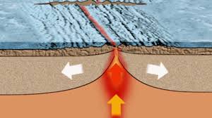
In sea-floor spreading, molten material rises from the mantle and erupts

1

along the edges of all the continents.

2

along mid-ocean ridges.

3

in deep-ocean trenches.

4

at the north and south poles.

46

Multiple Choice

Question image
What is the difference in elevation between Point X and Point Y?
1
120 m
2
240 m
3
360 m
4
340 m

47

Multiple Choice

Question image
What is the elevation of point B?
1
800 ft
2
850 ft
3
900 ft
4
1000 ft

48

Multiple Choice

Question image

Match the topographic map to its profile picture.

1
2
3
4

49

Multiple Choice

Question image

Match the topographic map to its profile.

1
2
3
4

50

Multiple Choice

Question image

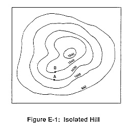
If the lines are close together on the map, it means that the rise/drop is ________________

1

Steep

2

Gradual

51

Multiple Choice

Question image

If the lines are far apart, it means it is a slow or ________________ rise/drop

1

Gradual

2

Steep

Topographic maps

Slide image

Show answer

Auto Play

Slide 1 / 51

SLIDE