Search Header Logo
Chapter 2 Gallopade TN Version

Chapter 2 Gallopade TN Version

Assessment

Presentation

•

Social Studies

•

3rd Grade

•

Practice Problem

•

Medium

Created by

Deanna Smith

Used 16+ times

FREE Resource

14 Slides • 19 Questions

1

Chapter 2 Gallopade TN Version

Locations on Earth

Slide image

2

3

Absolute Location

  • Absolute Location: the exact location of a place.

  • North Pole: Farthest point North.

  • South Pole: farthest point south

Slide image

4

Multiple Choice

Question image

Which pole is this?

1

north

2

south

5

Multiple Choice

Question image

Which pole is this?

1

north

2

south

6

7

Imaginary Lines

  • equator: A line that runs horizontally around the earth.

  • prime meridian: Runs vertically between north and south pole,

  • Hemispheres: divides the world in 2 halves.

Slide image

8

Slide image


9

Open Ended

Explain the pros and cons of living in a country along the equator?

10

11

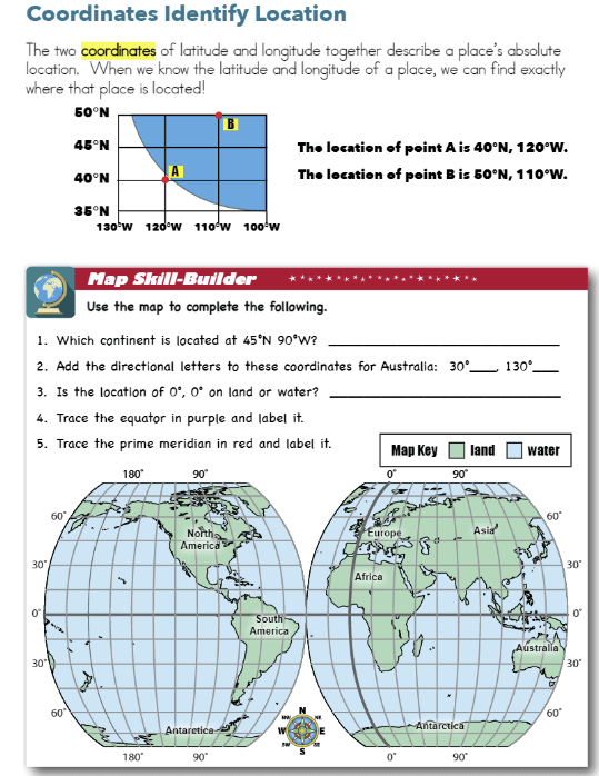
Parallels of Latitude and Longitude

  • latitude: imaginary circles around the earth.

  • longitude: Imaginary lines that run between the north and south pole.

  • grid: imaginary lines that make boxes to find exact locations.

Slide image

12

Slide image

13

14

Slide image

15

Slide image

16

17

Slide image

18

Multiple Choice

Question image

Answer the picture.

1

1. A 2. B

2

1. B 2. A

19

Multiple Choice

Question image

What is your answers to these?

1

1. equator 2. Primer Meridian

2

1. Prime Meridian 2. equator

20

Multiple Choice

The equator and the prime meridian each divide Earth in two halves called_____.

1

meridian

2

hemispheres

3

coordinates

4

poles

21

Multiple Choice

The equator is which type of line?

1

lines of longitude

2

lines of latitude

22

Multiple Choice

The prime meridian is what type of line?

1

lines of longitude

2

lines of latitude

23

Multiple Choice

Latitude is measured in degrees__________

1

east or west of the prime meridian

2

east or west of the equator

3

north or south of the equator

4

North and south of the prime meridian

24

Multiple Choice

longitude is measured in degrees _______

1

north and south of the equator

2

east or west of the equator

3

north or south of the prime meridian

4

east or west of the prime meridian

25

Multiple Choice

Which statement accurately describes lines of latitude and longitude?

1

They can be used to identify the exact location of any place on the surface of Earth.

2

They have been replaced by GpS and modern map tools, and rarely use them today.

26

Multiple Choice

Which statement best describes regions?

1

Regions are areas on a map or globe that are located at the same longitude.

2

Regions are areas on a map or globe with one or more characteristics.

3

Regions are areas on a map or globe that are located at the same latitude

27

Multiple Choice

Question image

What time zone is Tennessee in?

1

Eastern and Mountain

2

Mountain

3

Eastern

4

Eastern and Central

28

Multiple Choice

Question image

Which statement best describes the places on this map?

1

They are regions.

2

They are continents.

3

They are countries

29

Multiple Choice

Question image

Look at Map,

What city is at 33N latitude and 112W longitude?

1

Phoenix

2

Raleigh

3

Fargo

4

Portland

5

Houston

30

Multiple Choice

Question image

Look at Map,

What city is at 35N latitude and 78W longitude?

1

Phoenix

2

Raleigh

3

Fargo

4

Portland

5

Houston

31

Multiple Choice

Question image

Look at Map,

What city is at 46N latitude and 96W longitude?

1

Phoenix

2

Raleigh

3

Fargo

4

Portland

5

Houston

32

Multiple Choice

Question image

Look at Map,

What city is at 45N latitude and 122W longitude?

1

Phoenix

2

Raleigh

3

Fargo

4

Portland

5

Houston

33

Multiple Choice

Question image

Look at Map,

What city is at 29N latitude and 95W longitude?

1

Phoenix

2

Raleigh

3

Fargo

4

Portland

5

Houston

Chapter 2 Gallopade TN Version

Locations on Earth

Slide image

Show answer

Auto Play

Slide 1 / 33

SLIDE