
Review DAY 1-Boundaries-Topo-R&R
Presentation
•
Science
•
8th Grade
•
Medium
+3
Standards-aligned

Amber Gilbert
Used 9+ times
FREE Resource
4 Slides • 18 Questions
1
TEST Review
Plate Boundaries
Topography
R and R

2
3
Multiple Choice

The San Andreas Fault is a transform fault. The map shows a student's approximation of where the fault line crosses through the United States. Students were asked to make maps predicting which way land would most likely move over thousands of years. Which map best predicts the likely movement of land along the fault line over thousands of years.
4
Multiple Choice
5
Multiple Choice

Rift valleys can form when fractures in Earth’s crust widen. The valley walls slowly move at a rate of only a few millimeters a year. Which of these best describes the type of tectonic activity that forms rift valleys?
6
Multiple Choice

7
Multiple Choice

Which statement best describes the geologic process that is most likely responsible for the formation of mountains?
8
Multiple Choice

9
Multiple Choice

The model below shows two continental plates. The folded mountains in this model form at which type of plate boundary?
10
Multiple Choice

The model shows Earth in several positions relative to the sun. In which position is it winter in North America?
11
12
Multiple Choice
13
Multiple Choice

14
Multiple Choice

15
Multiple Choice

A satellite image of a river is provided.
The river shown in the satellite image is carrying sediments in which direction?
16
Multiple Choice

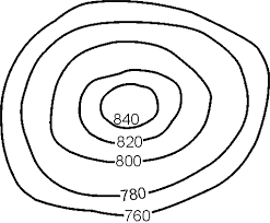
What is the difference in elevation between Point X and Point Y?
17
18
Multiple Choice

Which season is taking place in the Northern Hemisphere in Position 3?
19
Multiple Choice

20
Multiple Choice

21
Multiple Choice
22
Multiple Choice

TEST Review
Plate Boundaries
Topography
R and R
Show answer
Auto Play
Slide 1 / 22
SLIDE
Similar Resources on Wayground

19 questions
Introduction to The Cell Cycle
Lesson
•
7th Grade
15 questions
Listening to Earth
Lesson
•
7th Grade
19 questions
Plate Tectonics Day 2
Lesson
•
8th Grade
16 questions
Weather Fronts
Lesson
•
KG
20 questions
Tectonic Plates
Lesson
•
8th Grade
20 questions
Plate Boundaries
Lesson
•
8th Grade
19 questions
M/J Comp Sci 3 Earth Sun & Moon Review
Lesson
•
8th Grade
19 questions
PMA 3 Review-Climate & Weather
Lesson
•
8th Grade
Popular Resources on Wayground
8 questions
Spartan Way - Classroom Responsible
Quiz
•
9th - 12th Grade
15 questions
Fractions on a Number Line
Quiz
•
3rd Grade
14 questions
Boundaries & Healthy Relationships
Lesson
•
6th - 8th Grade
20 questions
Equivalent Fractions
Quiz
•
3rd Grade
3 questions
Integrity and Your Health
Lesson
•
6th - 8th Grade
25 questions
Multiplication Facts
Quiz
•
5th Grade
9 questions
FOREST Perception
Lesson
•
KG
20 questions
Main Idea and Details
Quiz
•
5th Grade
Discover more resources for Science
22 questions
Phases of the moon
Quiz
•
8th Grade
20 questions
Waves and Wave Properties
Quiz
•
6th - 8th Grade
8 questions
Amoeba Sister Asexual vs Sexual Reproduction
Interactive video
•
8th Grade
10 questions
Exploring the Rock Cycle: Types and Formation
Interactive video
•
6th - 8th Grade
20 questions
8th Grade Science STAAR Review
Quiz
•
8th Grade
22 questions
Newton's Laws of Motion
Lesson
•
8th Grade
9 questions
Seasons and Earth's Tilt
Lesson
•
6th - 8th Grade
10 questions
Exploring the Evolution of the Peppered Moth
Interactive video
•
6th - 10th Grade