
10/17 - Weather Maps and Symbols
Presentation
•
Science
•
8th Grade
•
Easy
Standards-aligned
Rebecca Keith
Used 198+ times
FREE Resource
13 Slides • 11 Questions
1
Weather Maps and Symbols
2
3
4
5
6
7
8
9
10
11
12
13
14
Multiple Choice
Near which city is the high pressure system located?
Seattle
Minneapolis
Dallas
Chicago
15
Multiple Choice
Near which two cities are the low pressure systems located?
Seattle & San Francisco
Chicago & Seattle
Dallas & Houston
Chicago & Nashville
16
Multiple Choice
What type of weather is generally associated with a low pressure system?
fair-weather, beautiful clear skies
Cloudy skies, some moist air, possible precipitation, stormy weather
cloudy skies, dry air
cloudy with a chance of meatballs
17
Multiple Choice
cold front
warm front
high pressure
low pressure
18
Multiple Choice
cold front
warm front
high pressure
low pressure
19
Multiple Choice
cold front
warm front
high pressure
low pressure
20
Multiple Choice
cold air moving into an area
warm air moving into an area
humid air over an area
dry air over an area
21
Multiple Choice
Which two cities are most likely to experience clear, dry weather?
Seattle & San Francisco
Chicago & Minneapolis
Chicago & Nashville
Dallas & Houston
22
Multiple Choice
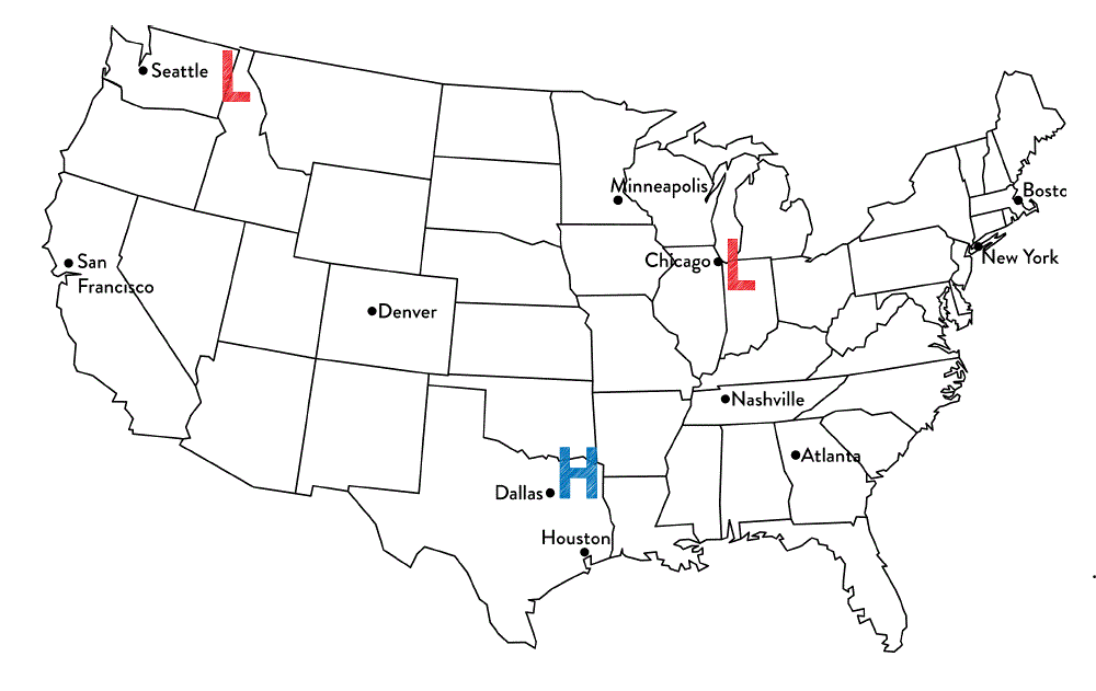
Tim said that Chicago is most likely to experience rainy weather. Jennifer thinks that Dallas is most likely to experience rainy weather.
Which student is correct?
Tim because Chicago is the closest to a low pressure system and they produce precipitation.
Jennifer because high pressure systems produce precipitation
Both students are correct because all systems produce precipitation
Neither of the students are correct because the cities are not close enough to the system.
23
Multiple Choice
What type of weather is associated with a high pressure system?
clear skies & moist air
cloudy skies & dry air
cloudy skies & moist air
clear skies & dry air
24
Multiple Choice
Which location is most likely experiencing warmer temperatures and higher humidity?
Location A
Location B
Location C
Location D
Weather Maps and Symbols
Show answer
Auto Play
Slide 1 / 24
SLIDE
Similar Resources on Wayground
21 questions
SSA Review
Presentation
•
8th Grade
15 questions
Ecosystems Review
Presentation
•
8th Grade
19 questions
Carbon and Nitrogen
Presentation
•
9th Grade
18 questions
7.10B Biodiversity
Presentation
•
7th Grade
21 questions
States & Composition of Matter
Presentation
•
8th Grade
16 questions
Newton's 2nd and 3rd Law
Presentation
•
8th Grade
16 questions
8.E.2.2
Presentation
•
8th Grade
18 questions
Fossils and Geologic Time Review
Presentation
•
8th Grade
Popular Resources on Wayground
10 questions
Factors 4th grade
Quiz
•
4th Grade
10 questions
Cinco de Mayo Trivia Questions
Interactive video
•
3rd - 5th Grade
13 questions
Cinco de mayo
Interactive video
•
6th - 8th Grade
20 questions
Math Review
Quiz
•
3rd Grade
20 questions
Main Idea and Details
Quiz
•
5th Grade
20 questions
Context Clues
Quiz
•
6th Grade
20 questions
Inferences
Quiz
•
4th Grade
19 questions
Classifying Quadrilaterals
Quiz
•
3rd Grade
Discover more resources for Science
16 questions
Interactions within Ecosystems
Presentation
•
6th - 8th Grade
20 questions
Moon Phases and Eclipses
Quiz
•
6th - 8th Grade
45 questions
8th Grade Science - EOG Review
Quiz
•
8th Grade
49 questions
NC Released EOG 8 Science (2024)
Quiz
•
8th Grade
48 questions
8th Grade NC Science EOG Review 2
Quiz
•
8th Grade
10 questions
Exploring Earth's Seasons and Their Causes
Interactive video
•
6th - 8th Grade
10 questions
The Ocean's Role in Weather and Climate
Interactive video
•
6th - 8th Grade
10 questions
Evidence of Evolution
Presentation
•
6th - 8th Grade