Search Header Logo
topography Staar Review Day 10

topography Staar Review Day 10

Assessment

Presentation

•

Science

•

•

Practice Problem

•

Easy

•
NGSS
MS-ESS2-4, MS-ESS2-3

Standards-aligned

Created by

Alex Davila

Used 12+ times

FREE Resource

9 Slides • 14 Questions

1

Topographic Maps

media

2

Topographic Map

View from above

Shows elevation above sea level

Show shape of land

media

3

media

4

media

5

media

6

Multiple Choice

Question image

Observe the image. Between which 2 points is the slope steeper?

1

A to B

2

C to D

7

Multiple Choice

Question image

Which side is steeper?

1

The left side of the hill

2

The right side of the hill

8

Multiple Choice

Question image

If the lines are far apart, it means it is a slow or ________________ rise/drop

1

Gradual

2

Steep

9

media

10

Multiple Choice

Question image

How many peaks does this landform have?

1

None

2

1

3

2

4

3

11

Fill in the Blank

Question image

How many peaks does this mountain have?

12

media

13

Multiple Choice

Question image

Which direction is the river flowing on this topo map?

1

Northeast

2

Southwest

3

East

4

North

14

Contour Lines

  • Each line will increase or decrease

  • The contour interval is how much it increases by

media

15

Multiple Choice

Question image

What is the elevation of Point A

1

15 meters

2

10 meters

3

20 meters

4

30 meters

16

Difference in elevation

To find the difference between 2 points, you get their values and subtract

media

17

Multiple Choice

Question image

What is the difference in elevation between point A and B?

1

760 m

2

820 m

3

60 m

4

20 m

18

Multiple Choice

Question image
Which topographic map matches formation C?
1

1

2

2

3

3

4

4

19

Multiple Choice

If contour lines are close together, then the slope is
1

gentle

2

steep

3

flat

4

going up and down

20

Multiple Choice

Question image

What is the elevation of point B?

1

800 ft

2

850 ft

3

900 ft

4

1000 ft

21

Multiple Choice

Question image

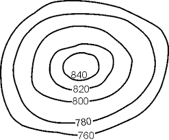
Determine the contour interval:

1

5 m

2

10 m

3

15 m

4

20 m

22

Multiple Choice

Question image

Match the topographic map to its profile.

1
2
3
4

23

Multiple Choice

Question image

If the lines are close together on the map, it means that the rise/drop is ________________

1

Steep

2

Gradual

Topographic Maps

media

Show answer

Auto Play

Slide 1 / 23

SLIDE