

Elements of a Map

Presentation
•
Social Studies
•
6th Grade
•
Hard

Joseph Anderson
FREE Resource
10 Slides • 17 Questions
1
Unit 1
Understanding Map Elements: Compass Rose, Scale, Legend, and Intermediate Directions
Ms. Griesbach.
6th Grade
2
Absolute Location vs Relative Location
Absolute Location
: The coordinates of a place pinpoint its absolute location, providing an exact position on the Earth's surface.
Relative Location
: When describing a location in relation to other places or landmarks, you are referring to its relative location.
3
Multiple Choice
What is Absolute Location?
Describing a location in relation to other places or landmarks.
Providing the exact coordinates of a place on Earth's surface.
Referring to the distance north or south of the equator.
Referring to the distance east or west of the Prime Meridian.
4
Multiple Choice
What does Relative Location refer to?
Providing the exact coordinates of a place on Earth's surface.
Describing a location in relation to other places or landmarks.
Referring to the distance north or south of the equator.
Referring to the distance east or west of the Prime Meridian.
5
Multiple Choice
What direction do lines of Longitude run on a map?
East to West.
North to South.
Northeast to Southwest.
Northwest to Southeast.
6
Coordinates, Latitude, and Longitude
Coordinates
: The combination of latitude and longitude is commonly used to express a precise location on the Earth's surface.
Latitude
: This is the distance east or west of the Prime Meridian, also measured in degrees.
Longitude
: This is the distance north or south of the equator, measured in degrees.
7
Multiple Choice
What are Coordinates used for?
Describing the distance north or south of the equator.
Referring to the distance east or west of the Prime Meridian.
Expressing a precise location on the Earth's surface.
Displaying cardinal and intermediate directions.
8
Multiple Choice
What direction do lines of Latitude run on a map?
East to West.
North to South.
Northeast to Southwest.
Northwest to Southeast.
9
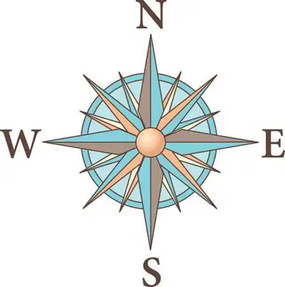
A compass rose is a figure that displays the orientation of the cardinal directions: North, South, East, and West, as well as the intermediate directions: Northeast, Southeast, Southwest, and Northwest. It is a vital tool for navigation, allowing the reader to understand which direction is which on the map.
Role of a Compass Rose
10
Multiple Choice
What is the primary function of a compass rose on a map?
Displaying the scale of the map.
Showing symbols or colors used on the map.
Representing the orientation of cardinal and intermediate directions.
Describing the human-environment interaction.
11
Culture and Society
: This term refers to a group of people living together in a community, sharing common interests and governance.
Society
: This term refers to the beliefs, customs, arts, and other manifestations of human intellectual achievement and lifestyle.
Culture
12
Multiple Choice
What does Culture refer to?
A group of people living together in a community.
Beliefs, customs, arts, and human intellectual achievements.
Representing cardinal and intermediate directions on a map.
The distance north or south of the equator.
13
Multiple Choice
What does Society refer to?
Beliefs, customs, arts, and human intellectual achievements.
A tool for navigation.
A group of people living together in a community.
Describing the interaction between humans and their environment.
14


:tells the subject of the map
Title
:This element tells you about the interaction between humans and their environment.
Human-Environment Interaction
15
Multiple Choice
What does the title of a map do?
Tells you about the subject of the map.
Represents cardinal and intermediate directions on a map.
Describes the interaction between humans and their environment.
Shows the distance on Earth's surface.
16
Multiple Choice
What does the element "Human-Environment Interaction" on a map tell you about?
The subject of the map.
The distance on Earth's surface.
Describes the interaction between humans and their environment.
Lists essential map elements.
17
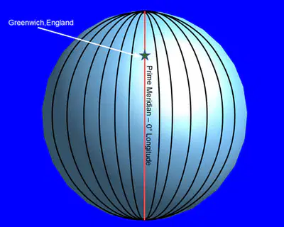
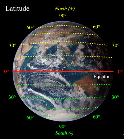
: lines run east to west.
Latitude
:lines run north to south.
Longitude
18
Multiple Choice
How do lines of Latitude run on a map?
East to West.
North to South.
Both East to West and North to South.
hey do not follow a specific direction.
19
Multiple Choice
How do lines of Longitude run on a map?
East to West.
North to South.
Both East to West and North to South.
They do not follow a specific direction.
20

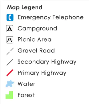
:shows you how much distance on the map represents distance on earth.
Scale
:shows you what certain symbols or colors used on the map represent.
Legend
21
Multiple Choice
What does the Scale on a map show?
How much distance on the map represents distance on Earth.
What certain symbols or colors used on the map represent.
The orientation of cardinal and intermediate directions.
Describes the interaction between humans and their environment.
22
Multiple Choice
What does the Legend on a map show?
How much distance on the map represents distance on Earth.
What certain symbols or colors used on the map represent.
The distance east or west of the Prime Meridian.
A group of people living together in a community.
23
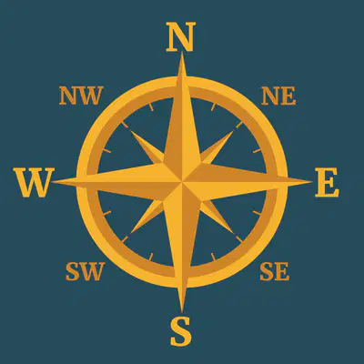
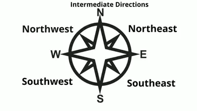
:shows the cardinal directions of north, south, east, and west.
Compass Rose
:the points on a compass rose that fall between the cardinal directions. (Northwest, Northeast, Southwest, and Southeast.
Intermediate Direction
24
Multiple Choice
What are the points on a compass rose that fall between the cardinal directions?
North and South.
East and West.
Northeast, Northwest, Southeast, and Southwest.
Latitude and Longitude.
25
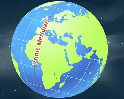
The Prime Meridian is an imaginary line that divides the Earth into Eastern and Western Hemispheres. It is considered the starting point for measuring longitude, which tells us how far places are from east to west.
Prime Meridian
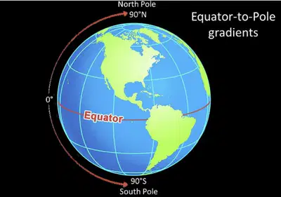
The Equator is an imaginary line that circles the Earth horizontally. It divides the Earth into Northern and Southern Hemispheres. The Equator is important because it marks the halfway point between the North Pole and the South Pole, and it also helps us understand latitude, which measures how far places are from north to south.
Equator
26
Multiple Choice
What is the Prime Meridian?
An imaginary line dividing the Earth into Northern and Southern Hemispheres.
A line that measures latitude.
A line that marks the halfway point between the North Pole and the South Pole.
An imaginary line dividing the Earth into Eastern and Western Hemispheres.
27
Multiple Choice
What is the Equator?
An imaginary line circling the Earth horizontally, marking the halfway point between the North Pole and the South Pole.
A line that measures longitude.
An imaginary line dividing the Earth into Eastern and Western Hemispheres.
An imaginary line dividing the Earth into Northern and Southern Hemispheres.
Unit 1
Understanding Map Elements: Compass Rose, Scale, Legend, and Intermediate Directions
Ms. Griesbach.
6th Grade
Show answer
Auto Play
Slide 1 / 27
SLIDE
Similar Resources on Wayground

20 questions
The Olympic Games - The past and the present
Presentation
•
6th Grade
18 questions
Buddhism
Presentation
•
6th Grade
22 questions
01/14 The Rule of Pericles and Athenian Life
Presentation
•
6th Grade
20 questions
Geography and the Early Settlement of China
Presentation
•
6th Grade
20 questions
Chapter 4 Section 1
Presentation
•
6th Grade
20 questions
Ancient India (Hinduism)
Presentation
•
6th Grade
19 questions
Impact of Geography on Latin America
Presentation
•
6th Grade
21 questions
The Puritans
Presentation
•
6th Grade
Popular Resources on Wayground
6 questions
Secondary Safety Quiz
Presentation
•
9th - 12th Grade
10 questions
Afterschool Activities & Sports

Quiz
•
6th - 8th Grade
19 questions
ROAR Week 2026
Quiz
•
9th - 12th Grade
20 questions
Lab Safety Quiz
Quiz
•
6th Grade
15 questions
Cool Tool:Chromebook
Quiz
•
6th - 8th Grade
22 questions
would you rather
Quiz
•
3rd - 11th Grade
21 questions
Continents and Oceans
Quiz
•
6th Grade
20 questions
Parts of Speech
Quiz
•
5th Grade
Discover more resources for Social Studies
14 questions
personal finance
Quiz
•
6th - 7th Grade
20 questions
Latitude and Longitude Practice
Quiz
•
6th Grade
10 questions
Chromebook User Agreement Multiple Choice Activity
Quiz
•
6th Grade
17 questions
Types of Government
Presentation
•
6th - 8th Grade
21 questions
Georgia's Geographic Regions
Quiz
•
6th - 8th Grade
34 questions
GRAPES of Civilization
Quiz
•
6th Grade
45 questions
Intro to Geography Study Guide
Quiz
•
6th Grade
16 questions
8 Strands of Social Studies - Review
Quiz
•
6th - 7th Grade