

Topographic Map

Presentation
•
Science
•
8th Grade
•
Hard

Joseph Anderson
FREE Resource
6 Slides • 14 Questions
1
Topographic Maps
8.9C Interpret topographic maps and satellite views to identify land and erosional features and predict how these features may be reshaped by weathering.

2
Contour Interval
The Contour Interval (CI) is the difference in elevation from one contour line to the next.
Usually, every line isn't marked so you have to determine the CI yourself.
Let's practice. What is the CI for this topographic map?

3
Multiple Choice

What is the contour interval on this map?
4
Multiple Choice

What is the contour interval (CI)?
5
Multiple Choice

What is the contour interval of this map?
6
Contour Lines
Lines that connect equal points of elevation.
Any POINT on that line will be the same elevation on that line.
First, what is the contour interval?
What is the elevation at point A?
Point B?

7
Multiple Choice

What height in meters must the student climb in order to reach the top of the hill? *Remember, the student is STARTING at POINT X.
8
Multiple Choice

A topographic map of a region is provided. Which position indicated by the letters is at an elevation of 475 meters?
9
Multiple Choice

10
STEEP Slopes
With STEEP slopes, hard to climb, lines would be close together. The STEEP slope of this landform is on the East side.

11
Multiple Choice

Which side is steeper?
12
Multiple Choice

13
Multiple Choice

Match the topographic map to its profile.
14
GENTLE Slope
With GENTLE slopes, easy to climb, lines would be spread apart together. The GENTLE slope on this landform would be on the West side.

15
Multiple Choice

Which point, A or B, has a gentle slope?
16
Multiple Choice

Which side of the landform has a gentle slope?
17
Water
A v-shape or u-shaped pattern on a topographic map is used to show a river or stream. The point of the V or the U points to the source of water. Remember, Water flows from a HIGH point to a LOW point. GRAVITY!
Which direction does this RIVER flow?

18
Multiple Choice

19
Multiple Choice
20
Multiple Choice

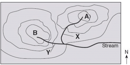
The topographic map pictured here shows a river flowing in which direction?
Topographic Maps
8.9C Interpret topographic maps and satellite views to identify land and erosional features and predict how these features may be reshaped by weathering.
Show answer
Auto Play
Slide 1 / 20
SLIDE


