Search Header Logo
10.1 Physical Geography of China and Mongolia

10.1 Physical Geography of China and Mongolia

Assessment

Presentation

Geography

6th - 8th Grade

Practice Problem

Easy

Created by

Linsey Smith

Used 3+ times

FREE Resource

22 Slides • 7 Questions

1

media

2

Poll

Question image

Would you rather...

Ride a unicorn

Ride a dragon

3

media

4

media

5

media

6

media

7

Labelling

Label the map of East Asia.

Drag labels to their correct position on the image

China

Japan

North Korea

8

media

9

media

10

media

11

media

12

Match

Question image

Using the map , match the physical description to the country or countries.

covers most of East Asia

landlocked

A peninsula

An archipelago

an island

China

Mongolia

North Korea and South Korea

Japan

Taiwan

13

media

14

media

15

Multiple Choice

Question image

Which statement about China's eastern plains is NOT true?

1

The plains support the farming of rice and soybeans.

2

The plains have rich deposits of natural resources that can be mined.

3

The plains are China's most densely populated areas.

4

The plains are known for their clean air.

16

media

17

media

18

media

19

media

20

Multiple Select

Question image

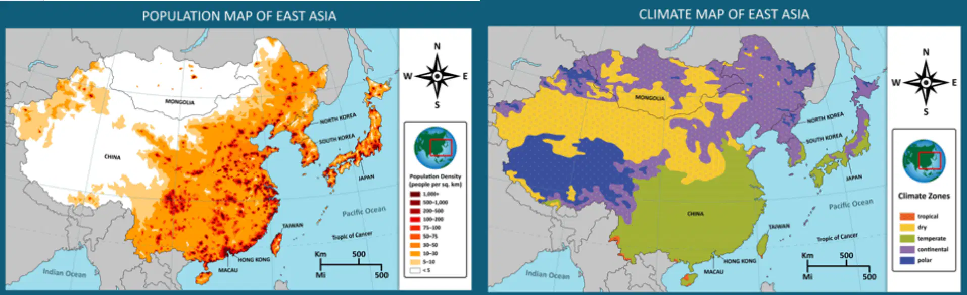
Examine the climate map and the population density map.

What conclusions can you draw?

Choose two answers.

1

Eastern China's population is denser than western China's.

2

China's most populated areas are in the temperate climate zone.

3

China's dry climate zone areas are mostly located in the east.

21

media

22

media

23

media

24

media

25

Open Ended

Question image

Using the maps and what you have learned about Mongolia, explain one reason why the population of the country is not dense.

26

media

27

media

28

media

29

Open Ended

Answer ONE of the questions below.

  1. Explain one way China's geography affects where or how people live.

  2. Explain one way Mongolia's geography affects where or how people live.

media

Show answer

Auto Play

Slide 1 / 29

SLIDE