

IAS-Hazards-Drought

Presentation
•
Geography
•
KG - Professional Development
•
Practice Problem
•
Easy

Aimee Cooper
Used 1+ times
FREE Resource
34 Slides • 28 Questions
1
Drought as a Hydro-Meteorological Hazard
By Aimee Cooper
2
Drought as a Hydro-Meteorological Hazard
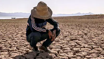
Drought is one of the world’s most widespread natural hazards. Unlike earthquakes or floods, it develops slowly over time as precipitation deficits accumulate. This lesson explores the causes, types, spatial distribution, and the ways in which drought becomes a hazard when it interacts with vulnerable population
3
Learning Objectives
Define and distinguish between the main types of drought.
Explain the physical and human causes of drought.
Describe global patterns and climatic links.
Interpret drought data and maps to analyse spatial patterns.
Assess why drought becomes a hazard.
4
Open Ended
At what point does a water shortage become a hazard?
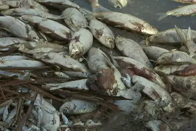
5
Defining Drought
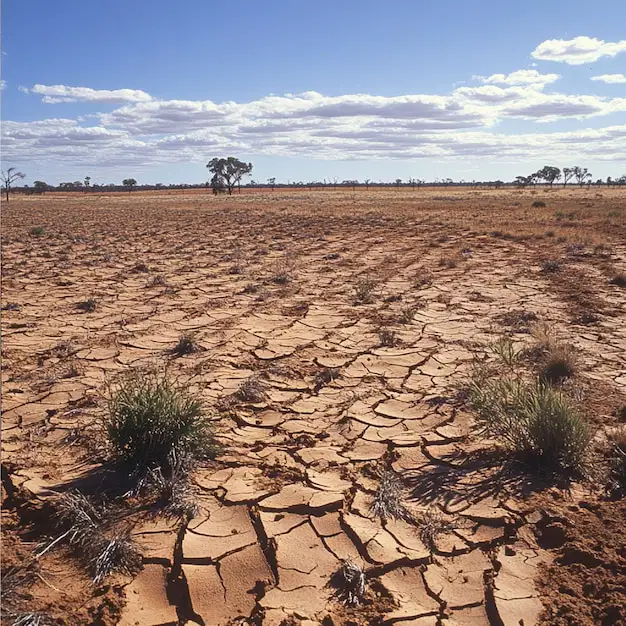
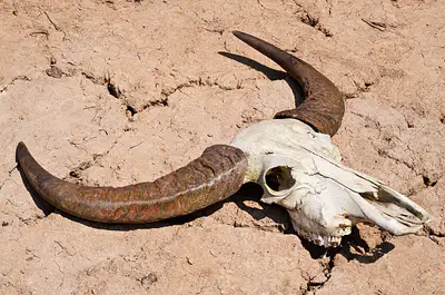
Drought is a temporary but prolonged period of below-average precipitation leading to water shortages that impact ecosystems, people, and economic activity.
It differs from aridity, which is a permanent climatic condition. Drought can occur in any climate zone when the balance between inputs (precipitation) and outputs (evaporation, transpiration, abstraction) is disturbed.
6
The Four Main Types of Drought
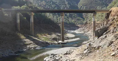
Meteorological Drought: Caused by a prolonged lack of precipitation relative to the long-term average.
Agricultural Drought: When soil moisture becomes insufficient for crops and vegetation.
Hydrological Drought: When rivers, lakes, and groundwater stores fall below normal levels.
Socio-economic Drought: When water shortages begin to affect people’s livelihoods, health, and the economy.
7
Match
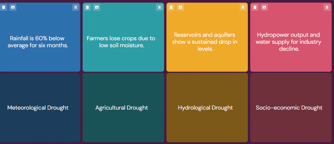
Match each description to its drought type
Rainfall is 60% below average for six months.
Farmers lose crops due to low soil moisture.
Reservoirs and aquifers show a sustained drop in levels.
Hydropower output and water supply for industry decline.
Meteorological Drought
Agricultural Drought
Hydrological Drought
Socio-economic Drought
Meteorological Drought
Agricultural Drought
Hydrological Drought
Socio-economic Drought
8
Open Ended
Why does meteorological drought usually occur first in the sequence?
9
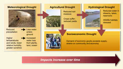
The Drought Cascade
Meteorological → Agricultural → Hydrological → Socio-economic.
Each type can trigger the next as impacts cascade through natural and human systems.
This temporal sequence helps geographers understand how a meteorological event can evolve into a complex hazard.
10
Open Ended
Explain why hydrological drought typically develops later than meteorological drought.
11
12
Physical Causes of Drought
The main meteorological drivers of drought are linked to global atmospheric circulation: Persistent high-pressure systems block depressions, preventing rainfall.
El Niño events shift convection eastwards, reducing rainfall in Australia and parts of Africa.
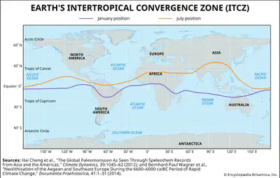
ITCZ (Inter-Tropical Convergence Zone) movements can leave regions like the Sahel dry for longer periods.
13
Multiple Choice
Which of the following best explains why Australia often experiences drought during El Niño?
Trade winds strengthen, increasing convection over Australia.
Warm water shifts eastwards, reducing uplift and rainfall in the western Pacific
Sea surface temperatures cool along the Peruvian coast.
Pressure falls over Australia.
14
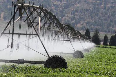
Human Factors Exacerbating Drought
Human activity can intensify the frequency and impact of drought: Over-abstraction of groundwater for agriculture.
Deforestation, reducing evapotranspiration and local rainfall recycling.
Unsustainable irrigation, increasing salinisation and water loss. Population pressure increasing water demand.
Drought hazard therefore arises from the interaction between natural deficits and human vulnerability.
15
Open Ended

Identify two regions currently experiencing extreme drought and explain how global circulation helps account for their location.
16
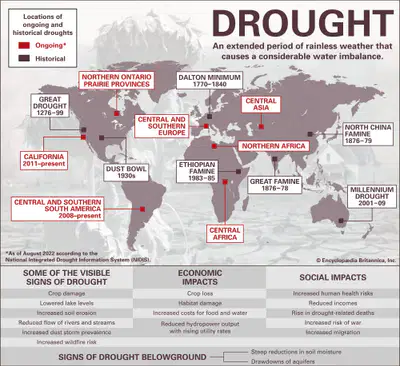
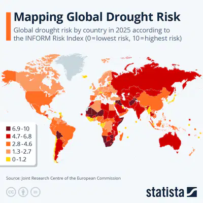
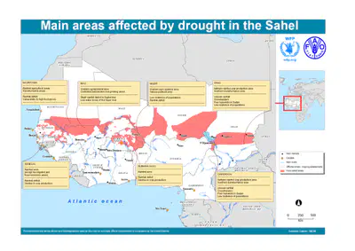
Drought is most common in subtropical latitudes (15°–35°) where descending air in the Hadley Cell creates persistent high pressure and limited rainfall.
High-risk areas include: Western and central Australia The Sahel region of Africa Southwest USA and Mexico Southern Africa The Middle East
Global Distribution of Drought Risk
17
Open Ended

Identify two distinct periods of prolonged drought.
Describe the overall pattern of rainfall variability since 1900.
Explain how this pattern reflects natural climate oscillations such as El Niño.
Consider whether drought events have become more frequent or intense in recent decades.
18
Open Ended
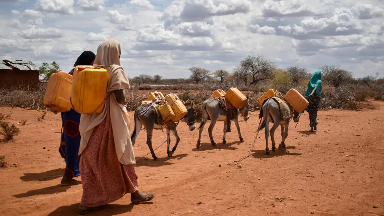
What are the impacts of drought?
19
Drought Impacts: When Shortage Becomes a Hazard
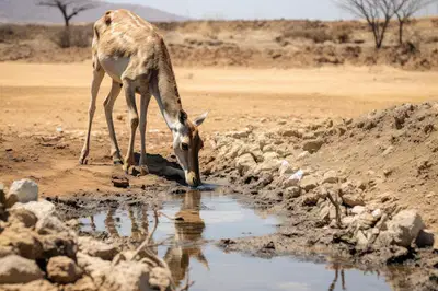
Drought becomes hazardous when physical shortages affect human and ecological systems:
Environmental: Loss of biodiversity, soil degradation, wildfire risk.
Social: Water scarcity, food insecurity, migration, health issues.
Economic: Agricultural loss, hydroelectric decline, reduced productivity.
20
Multiple Choice
Drought primarily causes economic losses but few environmental impacts.
True
False
21
Vulnerability and Capacity
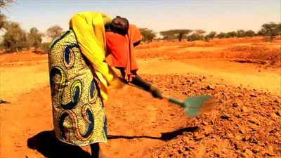
The severity of drought impacts depends on exposure and adaptive capacity. Developed regions (e.g. Australia, USA) face high economic losses but lower mortality. Developing regions (e.g. Sahel, Ethiopia) face high social vulnerability due to reliance on rain-fed agriculture and poor infrastructure.
22
Multiple Choice
Why is the Sahel region more vulnerable than Australia?
It receives less total rainfall.
It has less capacity to adapt and high dependence on rainfall
It experiences El Niño more frequently.
23
Recap: Key Takeaways
Drought is a slow-onset hydro-meteorological hazard. It can be classified as meteorological, agricultural, hydrological, or socio-economic.
It arises from both physical and human causes.
Distribution is linked to global circulation and climate oscillations.
Vulnerability transforms drought from a natural process into a disaster.

24
Australia Drought 2019–20: Background
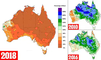
Australia often faces drought because it sits under the descending limb of the Hadley Cell, where dry air limits rainfall. The 2019–20 event was one of the worst on record, hitting New South Wales and Queensland especially hard. Soil dried out, rivers shrank, and the dry conditions helped trigger the catastrophic bushfires that followed.
25
Multiple Choice
Which atmospheric system explains Australia’s naturally dry climate?
ITCZ
Polar Front
The descending limb of the Hadley Cell
The Monsoon Trough
26
The Indian Ocean Dipole – A Key Driver of Drought in Australia
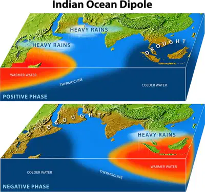
Australia’s droughts are strongly influenced by a natural climate pattern called the Indian Ocean Dipole (IOD). It works in a similar way to El Niño, but instead of the Pacific Ocean, it affects sea temperatures and rainfall across the Indian Ocean basin.
The IOD switches between two phases: Positive Phase: The waters near East Africa become warmer while those near Australia become cooler. This means less evaporation and less convection over Australia, leading to drier conditions.
Negative Phase: The pattern reverses — warmer waters near Australia encourage more convection and rainfall, bringing wetter conditions to northern and western Australia. When a positive IOD occurs at the same time as El Niño, Australia often experiences severe drought because both systems reduce rainfall.
27
What Caused It?
Several climate patterns combined to make this drought so severe:
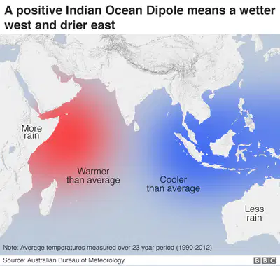
A positive Indian Ocean Dipole (IOD) cooled the waters near Australia and reduced rainfall.
The Subtropical Ridge shifted southwards, blocking rain-bearing systems.
Record-breaking heat increased evaporation and soil moisture loss.
Even though El Niño wasn’t active that year, the IOD effect alone was enough to produce one of the driest periods in decades.
28
29
Multiple Choice
How does a positive IOD lead to drought in Australia?
a) It cools nearby ocean waters, reducing convection and rainfall.
b) It warms nearby waters, increasing monsoon rainfall.
c) It strengthens trade winds from the Pacific.
d) It shifts the ITCZ northwards.
30
Environmental: Vegetation died back, wildlife habitats were destroyed, and fish died in the Murray–Darling Basin.
Social: Many towns faced water restrictions; rural communities suffered financially and emotionally.
Economic: Agricultural production fell sharply – the cotton and dairy industries were badly hit – costing billions of dollars overall.
Australia Drought Impacts
31
Categorize
Large-scale fish deaths in the Murray–Darling Basin
Major wildfires destroying over 12 million hectares of vegetation.
Long-term decline in soil fertility due to erosion and salinisation.
Towns such as Dubbo and Tamworth placed under severe water restrictions.
Increase in farmer suicides and rural mental health concerns.
Forced relocation of livestock to other states.
15% fall in national agricultural output during 2019.
Loss of tourism revenue as regional lakes and rivers dried up.
$5 billion fall in GDP linked to reduced exports of cotton and dairy.
Reduced hydroelectric power generation due to low reservoir levels.
Drag each statement into the correct category — Environmental, Social, or Economic.
32
Open Ended

How are these categories interconnected? For example, how might environmental degradation lead to economic loss and social strain?
33
How Did Australia Respond?
Australia’s response showed both its strengths and weaknesses.
Short-term actions included strict water restrictions, financial aid for farmers, and water transfers through the Murray–Darling Basin scheme.
Long-term measures focused on desalination, water recycling, and research into drought-resistant crops.
These helped reduce immediate hardship but couldn’t fully protect ecosystems or prevent huge economic losses.
34
35
Multiple Choice
Which of these is a long-term drought adaptation?
Emergency food relief
Desalination and water recycling
Tanker deliveries
Water rationing notices
36
Evaluating Australia
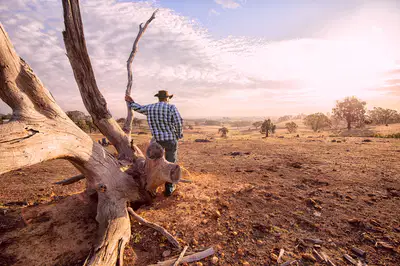
Australia’s case shows that wealth and planning reduce vulnerability but don’t remove risk completely. Water conflicts between states and industries are still common, and climate change is expected to make droughts more intense. Even a well-prepared country can’t stop a meteorological hazard – it can only limit the damage.
37
Open Ended

To what extent can effective management prevent drought from becoming a major hazard in a developed country like Australia?”
Point: State your argument (e.g. management can reduce but not eliminate risk).
Evidence: Use examples – desalination, water restrictions, economic losses, bushfire link.
Evaluate: Consider both sides – strong management vs uncontrollable physical causes.
38
From Developed to Developing
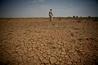
Australia shows how a wealthy country can prepare for drought but still suffer huge impacts. Now we turn to a region where drought has far more serious human consequences — the Sahel. Stretching across Africa from Senegal to Sudan, the Sahel is a semi-arid transition zone between the Sahara Desert and tropical savannas. Here, rainfall is highly variable, and even a small shift in seasonal rains can cause widespread famine and migration.
39
Open Ended
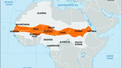
Describe the location of the Sahel. Why might it be at risk from drought?
40
Physical Causes of Drought in the Sahel
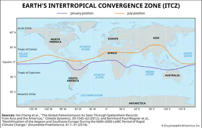
Rainfall in the Sahel depends on the north–south movement of the ITCZ (Inter-Tropical Convergence Zone).
When the ITCZ moves north during summer, it brings moist air and rainfall.
When it doesn’t move far enough north, rainfall fails.
Droughts occur when: The ITCZ stays too far south, keeping the Sahel dry.
Sea surface temperature anomalies in the Atlantic and Indian Oceans disrupt monsoon flow. Warmer global temperatures increase evaporation and reduce soil moisture.
41
Open Ended

Explain why a southward shift of the ITCZ can cause drought in the Sahel.
42
Feedbacks: Albedo and the Drought Cycle
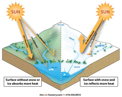
Drought in the Sahel is worsened by the albedo effect, a land–atmosphere feedback that reinforces dryness. When vegetation dies and soils dry out, the surface becomes lighter in colour and reflects more sunlight. This raises the albedo, meaning less energy is absorbed, the surface stays cooler, and less warm air rises to form clouds. With reduced convection and rainfall, vegetation struggles to return — locking the region into a self-perpetuating drought cycle.
43
Open Ended
How might reforestation projects like the Great Green Wall help reverse this albedo feedback?
44
Human Factors Making It Worse
Physical drought is intensified by human pressure on fragile environments: Overgrazing removes vegetation, exposing soils. Deforestation for fuelwood reduces moisture recycling
. Over-cultivation exhausts nutrients, accelerating erosion.
Rapid population growth increases pressure on land and water.
Political instability and conflict make coordinated management difficult.
These human pressures interact with natural climate variability to create a hazard chain of drought, land degradation, and food insecurity.

45
Multiple Choice

Which human factor most directly increases desertification in the Sahel?
Urbanisation
Overgrazing
Monsoon failure
Rising Global Temperatures
46
Open Ended
What will the impacts of drought be on the Sahel?
47
48
Categorize
Loss of vegetation cover across grazing lands, exposing soil to wind erosion.
Decline in crop yields of millet and sorghum due to shorter rainy seasons.
Desertification spreading southwards as fertile land becomes unproductive.
Increased frequency of sandstorms and dust events reducing air quality.
Loss of biodiversity and the spread of invasive, drought-tolerant species.
Food insecurity and malnutrition affecting millions across Niger, Chad, and Mali.
Rural–urban migration as young adults leave villages to find work or aid.
Children leaving school to collect water or support family farms
Health impacts such as disease outbreaks linked to poor nutrition and limited sanitation.
Women and girls walking longer distances for water, limiting time for education and work.
Famine declarations by international organisations in the worst-affected years.
Livestock deaths from dehydration and lack of fodder, reducing household wealth.
Rising food prices and market shortages leading to conflict over resources.
Reduced GDP growth and falling export earnings from agriculture and livestock.
Dependence on international aid creating long-term economic dependency.
Drag each statement into the correct impact category — Environmental, Social, or Economic.
49
Open Ended

Choose one impact from each category and explain how they are linked in a chain of cause and effect.
For example:
“Loss of vegetation (environmental) reduces grazing land, leading to livestock deaths (economic), which in turn reduces household income and increases food insecurity (social).”
50
Responses and Adaptations in the Sahel
During severe drought years, the first response often comes from international organisations and NGOs. The UN World Food Programme, UNICEF, and the Red Cross provide food aid, medical supplies, and clean water to affected communities. In the 2012 drought, for example, over 18 million people across the Sahel received emergency assistance. While this support saves lives, it is often short-term and can lead to dependency if not paired with sustainable development.

51
Multiple Choice
What is a key limitation of emergency food aid?
It permanently solves food insecurity.
It can create long-term dependency if overused.
It reverses land degradation.
It reduces birth rates.
52
Boreholes and Groundwater Extraction
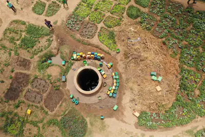
To improve access to water, many aid agencies and governments have drilled boreholes and installed hand pumps to reach groundwater reserves. These provide a vital local water source for drinking and livestock during dry periods. However, overuse can cause the water table to fall, and maintenance is often difficult in remote areas.
53
The Great Green Wall (GGW) is one of the most ambitious environmental projects in the world. It aims to create an 8,000 km belt of trees and vegetation across Africa’s Sahel region, from Senegal to Djibouti. The goal is to restore degraded land, reduce albedo, increase soil moisture, and improve local rainfall by stabilising the surface. Over 20 countries are involved, and more than 18 million hectares have already been restored.

54
Open Ended
How does the Great Green Wall address both environmental and social aspects of drought vulnerability?
55
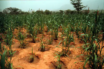
Local Agricultural Adaptation
Farmers are increasingly using small-scale, low-cost methods to cope with variable rainfall.
Techniques include: Zai pits (small planting holes that collect water and compost to retain soil moisture).
Contour bunds and stone lines to reduce runoff and erosion.
Drought-resistant crops such as millet, sorghum, and cowpea.
These methods restore fertility and increase yields even when rainfall is low.
56
Multiple Choice
Which of the following best describes zai pits?
57
Open Ended

Why are local farming methods often more sustainable than large-scale irrigation schemes in the Sahel?
58
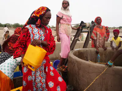
Education and Community Projects
Education plays a major role in reducing vulnerability.
Local NGOs train farmers in soil and water conservation, tree planting, and livelihood diversification.
Community groups also encourage women’s participation in water management and crop marketing.
Educated communities are more resilient and less dependent on external aid.
59
Evaluation: What Works Best?
Short-term measures like food aid and boreholes save lives but don’t solve the underlying causes of drought.
Long-term strategies like the Great Green Wall, agricultural adaptation, and education address environmental and social vulnerabilities directly.
However, these require stable governments, long-term funding, and regional cooperation.
60
Open Ended

“Assess the success of strategies used to manage drought in the Sahel region.”
61
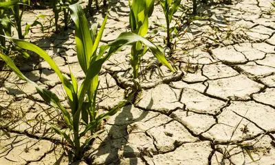
Even though Australia and the Sahel differ hugely in wealth, climate, and governance, both show that drought cannot be avoided – only managed. Physical drivers like global circulation and ocean–atmosphere oscillations are beyond human control, but the scale of impact depends on vulnerability and capacity. Resilience comes from planning, cooperation, and sustainable resource use, not just short-term relief.
62
Key Takeaways
Droughts are multi-cause hazards, triggered by both physical processes and human actions.
Effective management reduces vulnerability but cannot eliminate risk.
The best strategies are integrated – combining technology, education, environmental restoration, and governance.
Climate change is likely to make droughts more frequent and intense, especially in semi-arid regions.

Drought as a Hydro-Meteorological Hazard
By Aimee Cooper
Show answer
Auto Play
Slide 1 / 62
SLIDE
Similar Resources on Wayground

57 questions
Prehistory
Presentation
•
9th - 10th Grade
56 questions
Unit 3 Study Guide: Atoms & Periodic Table
Presentation
•
6th - 8th Grade
56 questions
Biodiversity Lesson
Presentation
•
9th - 12th Grade
62 questions
Plates, Topographic Maps, and Satelite Views Review
Presentation
•
6th - 8th Grade
57 questions
Africa Intro
Presentation
•
6th - 7th Grade
55 questions
Countries and Nationalities
Presentation
•
3rd - 7th Grade
59 questions
Ecosystems Revision!
Presentation
•
10th Grade
Popular Resources on Wayground
6 questions
Secondary Safety Quiz
Presentation
•
9th - 12th Grade
10 questions
MyPath Diagnostic Overview
Presentation
•
6th - 8th Grade
20 questions
Lab Safety Quiz

Quiz
•
6th Grade
21 questions
Continents and Oceans
Quiz
•
6th Grade
20 questions
Adding and Subtracting Decimals
Quiz
•
5th Grade
20 questions
Parts of Speech
Quiz
•
5th Grade
16 questions
Subject & Predicate
Quiz
•
5th Grade
21 questions
Lab Safety
Quiz
•
10th Grade
Discover more resources for Geography
21 questions
Continents and Oceans
Quiz
•
6th Grade
27 questions
Geo #2 Regions
Quiz
•
8th Grade
18 questions
Continents and Oceans
Quiz
•
5th Grade
50 questions
U.S. 50 States Map Practice
Quiz
•
5th - 8th Grade
7 questions
Types of Maps
Quiz
•
4th - 6th Grade
20 questions
Continents and Oceans
Quiz
•
6th Grade
17 questions
Map Skills
Quiz
•
6th Grade
13 questions
Geography Regions Test Review
Quiz
•
5th Grade