geography review
Authored by Kamau Daye
Geography
6th - 8th Grade

AI Actions
Add similar questions
Adjust reading levels
Convert to real-world scenario
Translate activity
More...
Content View
Student View
16 questions
Show all answers
1.
MULTIPLE CHOICE QUESTION
1 min • 1 pt
On a map, what shows the relationship between actual distance and distance shown on a map?
2.
MULTIPLE CHOICE QUESTION
30 sec • 1 pt
What is the name of the symbol that shows cardinal and intermediate directions?
3.
MULTIPLE CHOICE QUESTION
1 min • 1 pt
The Earth can be divided into how many hemispheres?
4.
MULTIPLE CHOICE QUESTION
2 mins • 1 pt

What is the name of this line at 0 degrees latitude?
5.
MULTIPLE CHOICE QUESTION
2 mins • 1 pt
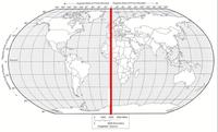
What is the name of the line at zero degrees longitude?
6.
MULTIPLE CHOICE QUESTION
3 mins • 1 pt

To locate a place on the earth, you need to look at...
7.
MULTIPLE CHOICE QUESTION
30 sec • 1 pt
Lines of Latitude can be measured up to what degree?
Access all questions and much more by creating a free account
Create resources
Host any resource
Get auto-graded reports
Continue with Google

Continue with Email
Continue with Classlink
Continue with Clever
or continue with
Microsoft
%20(1).png)
Apple
Others
Already have an account?
Similar Resources on Wayground

11 questions
Japan
Quiz
•
5th - 8th Grade
20 questions
Canada
Quiz
•
6th - 12th Grade
15 questions
PEP Social studies
Quiz
•
6th Grade
15 questions
Resources_4
Quiz
•
8th Grade
20 questions
Y6_Week1_Spring_2022
Quiz
•
6th Grade
15 questions
World Heritage Monuments
Quiz
•
5th - 6th Grade
15 questions
Land constraint, geography vocabulary term
Quiz
•
8th Grade
15 questions
Test B-Hatfield-McCoy Mountains/New River Greenbrier Valley
Quiz
•
8th Grade
Popular Resources on Wayground
15 questions
Fractions on a Number Line
Quiz
•
3rd Grade
10 questions
Probability Practice
Quiz
•
4th Grade
15 questions
Probability on Number LIne
Quiz
•
4th Grade
20 questions
Equivalent Fractions
Quiz
•
3rd Grade
25 questions
Multiplication Facts
Quiz
•
5th Grade
22 questions
fractions
Quiz
•
3rd Grade
6 questions
Appropriate Chromebook Usage
Lesson
•
7th Grade
10 questions
Greek Bases tele and phon
Quiz
•
6th - 8th Grade
Discover more resources for Geography
10 questions
Seasons and Earth's Tilt
Quiz
•
7th Grade
50 questions
U.S. 50 States Map Practice
Quiz
•
5th - 8th Grade
12 questions
Russia, Central Asia, & the Caucasus
Quiz
•
6th Grade
20 questions
Geography of Europe
Quiz
•
6th Grade
10 questions
38a, b, c: Voluntary trade in Africa
Quiz
•
7th Grade
10 questions
38a, b, c: Voluntary trade in Africa
Quiz
•
7th Grade
12 questions
SS6G12 Australia Location Climate Natural Resources
Quiz
•
6th Grade
40 questions
Geography of Latin America
Quiz
•
6th Grade