
APHG 1.1-1.3
9th - 12th Grade
•14 Qs

Similar activities
Unit 4 Exam Review (Scientific Revolution)
7th - 10th Grade
•15 Qs
Contours quiz
2nd Grade - University
•17 Qs
Europe Political Geography
9th Grade
•13 Qs
6th SS Map 1
KG - University
•13 Qs
Megacities and Urbanisation - Recap
7th - 9th Grade
•15 Qs
ยุโรปความรู้รอบตัว
9th - 12th Grade
•10 Qs
Primera Guerra Mundial - WWI
7th Grade - Professional Development
•19 Qs
Latin America Map - Self Assessment
9th Grade
•15 Qs

APHG 1.1-1.3
Quiz
•
Geography
•
9th - 12th Grade
•
Easy

WILLIAM BANE
Used 9+ times
FREE Resource
Enhance your content in a minute
14 questions
Show all answers
1.
MULTIPLE CHOICE QUESTION
30 sec • 1 pt

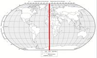
The dots on the map above prove that the Mercator map:
Fairly represents the size of Africa
Distorts direction and distance
Over-represents the size of items near the poles
Has lines of latitude that intersect
2.
MULTIPLE CHOICE QUESTION
30 sec • 1 pt
All map projections
Have some form of distortion
Show cities and borders
Show north facing up
Display the entirety of the Earth
3.
MULTIPLE CHOICE QUESTION
30 sec • 1 pt
The Census Bureau
Conducts a count of US citizens every ten years
Helps track absolute location using satellites
Can be used to create custom maps using layers
Creates new map projections that can be used by geographers
4.
MULTIPLE CHOICE QUESTION
30 sec • 1 pt

These maps show locations of places and geographic features
reference map
thematic map
5.
MULTIPLE CHOICE QUESTION
30 sec • 1 pt

These maps tell stories, typically showing the degree of some attribute or the movement of a geographic phenomenon
reference maps
thematic maps
6.
MULTIPLE CHOICE QUESTION
30 sec • 1 pt

This satellite-based system allows us to locate things on the surface of Earth with extraordinary accuracy
Global positioning system (GPS)
Geocaching
Geographic Information System (GIS)
Remote Sensing
7.
MULTIPLE CHOICE QUESTION
30 sec • 1 pt

_______________ combines layers of spatial data and creates maps in which patterns and processes are superimposed and seen
GIS - Geographic Information Systems
GPS - Global Positioning System
Remote Sensing
GDLS - Global Data Layer System

Access all questions and much more by creating a free account
Create resources
Host any resource
Get auto-graded reports
Continue with Google

Continue with Email
Continue with Classlink
Continue with Clever
or continue with
Microsoft
%20(1).png)
Apple
Others
Already have an account?
Similar Resources on Wayground
10 questions
Guess the Place
Quiz
•
KG - 10th Grade
10 questions
Grade 10 - Geography of United States (1)
Quiz
•
10th Grade
10 questions
Ukraine
Quiz
•
6th Grade - University
15 questions
Herhaling Par. 1.4 t/m 1.6 - Havo 5 - Globalisering
Quiz
•
11th Grade
10 questions
TURKEY
Quiz
•
9th - 11th Grade
15 questions
Grassland
Quiz
•
KG - Professional Dev...
10 questions
Settlements and Service Provision
Quiz
•
9th Grade
15 questions
Farming
Quiz
•
7th - 9th Grade
Popular Resources on Wayground
15 questions
Fractions on a Number Line
Quiz
•
3rd Grade
20 questions
Equivalent Fractions
Quiz
•
3rd Grade
25 questions
Multiplication Facts
Quiz
•
5th Grade
54 questions
Analyzing Line Graphs & Tables
Quiz
•
4th Grade
22 questions
fractions
Quiz
•
3rd Grade
20 questions
Main Idea and Details
Quiz
•
5th Grade
20 questions
Context Clues
Quiz
•
6th Grade
15 questions
Equivalent Fractions
Quiz
•
4th Grade
Discover more resources for Geography
45 questions
Unit 9 Europe Review
Quiz
•
9th Grade
25 questions
Population and Demography Quiz
Quiz
•
9th Grade
14 questions
Russia lesson 2 p363-371
Quiz
•
9th Grade
17 questions
Russia Lesson 3
Quiz
•
9th Grade
20 questions
AP Human Geography Unit 5
Quiz
•
10th Grade
11 questions
How do volcanoes and earthquakes happen?
Passage
•
9th Grade
15 questions
Population Pyramid
Quiz
•
9th Grade
30 questions
Unit 5 Exam: Russia and Central Asia
Quiz
•
10th Grade