APHG 1.1
Authored by Katherine Fletcher
Geography
9th - 12th Grade
Used 53+ times

AI Actions
Add similar questions
Adjust reading levels
Convert to real-world scenario
Translate activity
More...
Content View
Student View
15 questions
Show all answers
1.
MULTIPLE CHOICE QUESTION
30 sec • 1 pt

Which of the following is true of the above map?
It is a reference map.
It distorts size of countries to show a variable.
It is a cartogram.
Shades and colors represent differences in a variable.
2.
MULTIPLE CHOICE QUESTION
30 sec • 1 pt

The Red lines are showing what?
3.
MULTIPLE CHOICE QUESTION
30 sec • 1 pt

What type of map is being shown?
4.
MULTIPLE CHOICE QUESTION
2 mins • 1 pt
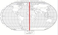
What is the name of the line at zero degrees longitude?
5.
MULTIPLE CHOICE QUESTION
2 mins • 1 pt

What is the name of this line at 0 degrees latitude?
6.
MULTIPLE CHOICE QUESTION
30 sec • 1 pt
Relative location is....
7.
MULTIPLE CHOICE QUESTION
30 sec • 1 pt
Representation of a real world phenomenon at a certain level of reduction or generalization (ex. local, regional, global)


Access all questions and much more by creating a free account
Create resources
Host any resource
Get auto-graded reports
Continue with Google

Continue with Email
Continue with Classlink
Continue with Clever
or continue with
Microsoft
%20(1).png)
Apple
Others
Already have an account?
Similar Resources on Wayground

10 questions
Extrativismo
Quiz
•
11th - 12th Grade
10 questions
Settlements and Service Provision
Quiz
•
9th Grade
13 questions
Culturas mesoamericanas y andinas
Quiz
•
9th Grade
10 questions
População: conceitos e Medidores sociais
Quiz
•
6th - 11th Grade
12 questions
La Influencia del sol sobre la tierra
Quiz
•
12th Grade
13 questions
Ecorregión del mar (Mar frío y Mar tropical)
Quiz
•
12th Grade
20 questions
Map to Actual Distance
Quiz
•
10th Grade
10 questions
Los Continentes
Quiz
•
1st - 12th Grade
Popular Resources on Wayground
7 questions
History of Valentine's Day
Interactive video
•
4th Grade
15 questions
Fractions on a Number Line
Quiz
•
3rd Grade
20 questions
Equivalent Fractions
Quiz
•
3rd Grade
25 questions
Multiplication Facts
Quiz
•
5th Grade
22 questions
fractions
Quiz
•
3rd Grade
15 questions
Valentine's Day Trivia
Quiz
•
3rd Grade
20 questions
Main Idea and Details
Quiz
•
5th Grade
20 questions
Context Clues
Quiz
•
6th Grade
Discover more resources for Geography
35 questions
Unit 5 Lesson 5 & 6 Quiz - Religions & Religious Conflict
Quiz
•
9th Grade
29 questions
Europe, SW Asia and N Africa Review
Quiz
•
10th Grade
20 questions
Mardi Gras History
Quiz
•
6th Grade - University
15 questions
Population Pyramid
Quiz
•
9th Grade
15 questions
Eastern Europe Map Quiz '25
Quiz
•
9th Grade
12 questions
Unit 3: Population Pyramid Practice
Quiz
•
9th Grade
46 questions
AP Human Geography Unit 4 Review
Quiz
•
9th - 12th Grade