
Unit 1 Review
5th - 8th Grade
•36 Qs

Similar activities
Chapter 4: American Revolution
6th - 8th Grade
•34 Qs
U.S. and Canada Civics Review
5th - 6th Grade
•35 Qs
Government Test
5th - 8th Grade
•39 Qs
Unit 7 Study Guide
8th Grade
•32 Qs
UNIT 7 CIVIL WAR- GR 7 TEXAS HISTORY
7th Grade
•41 Qs
Canadian Citizenship Modern Canada (Pages 24-27 Discover Canada)
8th Grade
•31 Qs
Latin America Unit Test
6th Grade
•39 Qs
Early Ancient Greece
6th Grade
•31 Qs

Unit 1 Review
Quiz
•
Social Studies, Geography
•
5th - 8th Grade
•
Medium

Suzanne Harris
Used 1+ times
FREE Resource
Enhance your content in a minute
36 questions
Show all answers
1.
MULTIPLE CHOICE QUESTION
1 min • 1 pt

What part of the map tells you what symbols mean?
2.
MULTIPLE CHOICE QUESTION
1 min • 1 pt

What is the title?
3.
MULTIPLE CHOICE QUESTION
1 min • 1 pt

This image represents Jim's---
mental map
map orientation
absolute location
directional indicator
4.
MULTIPLE CHOICE QUESTION
1 min • 1 pt

_________= the exact place on earth using exact coordinates.
Absolute Location
Relative Location
Mental Maps
Map Projections
5.
MULTIPLE CHOICE QUESTION
1 min • 1 pt
The _______________or key explains the marks or symbols that
are used in a map.
sketch
legend
atlas
scale
6.
MULTIPLE CHOICE QUESTION
1 min • 1 pt
The ratio between distance on the ground and distance on the
ground and distance on the map is called the:
scale
sketch
physical maps
aerial photograph
7.
MULTIPLE CHOICE QUESTION
1 min • 1 pt

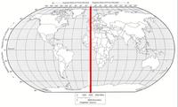
What is the name of this line at 0 degrees latitude?
Access all questions and much more by creating a free account
Create resources
Host any resource
Get auto-graded reports
Continue with Google

Continue with Email
Continue with Classlink
Continue with Clever
or continue with
Microsoft
%20(1).png)
Apple
Others
Already have an account?
Similar Resources on Wayground
36 questions
EOC Review 2024 (part 3)
Quiz
•
7th Grade
40 questions
Lesson 6 - Exploring Four Empires of Mesopotamia
Quiz
•
6th - 8th Grade
40 questions
Social Studies SIM Review
Quiz
•
8th Grade
40 questions
American Revolution Test Review QUIZIZZ
Quiz
•
8th Grade
34 questions
SOL Practice Test (2013)
Quiz
•
8th Grade
35 questions
Unit 7: Mexico Review
Quiz
•
7th Grade
34 questions
7th Grade - Module 2 Test Review - The Physical World
Quiz
•
7th Grade
40 questions
Oklahoma Geography Handbook Quiz
Quiz
•
6th Grade
Popular Resources on Wayground
15 questions
Fractions on a Number Line
Quiz
•
3rd Grade
20 questions
Equivalent Fractions
Quiz
•
3rd Grade
25 questions
Multiplication Facts
Quiz
•
5th Grade
54 questions
Analyzing Line Graphs & Tables
Quiz
•
4th Grade
22 questions
fractions
Quiz
•
3rd Grade
20 questions
Main Idea and Details
Quiz
•
5th Grade
20 questions
Context Clues
Quiz
•
6th Grade
15 questions
Equivalent Fractions
Quiz
•
4th Grade
Discover more resources for Social Studies
38 questions
The Patriot Way: Classroom, Hallway, and Commons
Quiz
•
7th Grade
24 questions
Republic of Texas and Early Statehood Test Review
Quiz
•
7th Grade
10 questions
Black History Month
Quiz
•
5th Grade
24 questions
Quiz #2- American Revolution
Quiz
•
7th Grade
24 questions
Republic of Texas Review
Quiz
•
7th Grade
17 questions
Early Statehood Review-3.0
Quiz
•
7th Grade
8 questions
Agriculture, Laws, and Slavery in Early Texas
Lesson
•
6th - 8th Grade
20 questions
Causes of the American Revolution
Quiz
•
5th Grade