8th - mapping
Authored by Lindsay Shaffer
Science, Geography
8th Grade
Used 7+ times

AI Actions
Add similar questions
Adjust reading levels
Convert to real-world scenario
Translate activity
More...
Content View
Student View
34 questions
Show all answers
1.
MULTIPLE CHOICE QUESTION
30 sec • 1 pt

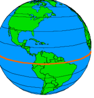
0 degrees latitude; an imaginary line that runs around the middle of Earth, like a belt
2.
MULTIPLE CHOICE QUESTION
30 sec • 1 pt

0 degrees longitude; an imaginary line that runs up and down through the United Kingdom
3.
MULTIPLE CHOICE QUESTION
1 min • 1 pt

What is the approximate location of letter B?
4.
MULTIPLE CHOICE QUESTION
1 min • 1 pt
Contour lines that are very close together indicate the land is _______________
5.
MULTIPLE CHOICE QUESTION
30 sec • 1 pt
Map that shows detailed shapes of Earth's surface, along with its natural and human made features
6.
MULTIPLE CHOICE QUESTION
30 sec • 1 pt
Lines on a topographic map that connect points of equal elevation
7.
MULTIPLE CHOICE QUESTION
30 sec • 1 pt
The angular distance measured in degrees North or South of the equator is called ___.


Access all questions and much more by creating a free account
Create resources
Host any resource
Get auto-graded reports
Continue with Google

Continue with Email
Continue with Classlink
Continue with Clever
or continue with
Microsoft
%20(1).png)
Apple
Others
Already have an account?
Similar Resources on Wayground

0 questions
Final Review~Mapping
Quiz
•
0 questions
Spheres, Mapping, Latitude & Longitude Test Review
Quiz
•
0 questions
Mapping Unit Test Review
Quiz
•
0 questions
Mapping Unit Review
Quiz
•
0 questions
Mapping Extra Credit
Quiz
•
0 questions
Latitude and Longitude
Quiz
•
0 questions
ES Mapping 2020
Quiz
•
Popular Resources on Wayground
5 questions
This is not a...winter edition (Drawing game)
Quiz
•
1st - 5th Grade
25 questions
Multiplication Facts
Quiz
•
5th Grade
10 questions
Identify Iconic Christmas Movie Scenes
Interactive video
•
6th - 10th Grade
20 questions
Christmas Trivia
Quiz
•
6th - 8th Grade
18 questions
Kids Christmas Trivia
Quiz
•
KG - 5th Grade
11 questions
How well do you know your Christmas Characters?
Lesson
•
3rd Grade
14 questions
Christmas Trivia
Quiz
•
5th Grade
20 questions
How the Grinch Stole Christmas
Quiz
•
5th Grade
Discover more resources for Science
20 questions
Name That Tune Christmas Edition
Quiz
•
6th - 9th Grade
18 questions
Christmas Science
Quiz
•
6th - 8th Grade
37 questions
8.10B Weather Patterns
Quiz
•
8th Grade
10 questions
Exploring Plate Tectonics and Their Boundaries
Interactive video
•
6th - 10th Grade
22 questions
Amplify - Traits and Reproduction
Quiz
•
8th Grade
15 questions
Snow
Quiz
•
6th - 8th Grade
15 questions
Movie Trivia for Christmas
Quiz
•
6th - 8th Grade
20 questions
Cell Organelles and Functions
Quiz
•
6th - 8th Grade