Topographic Map
Authored by JR Thompson
Science
4th - 6th Grade
NGSS covered
Used 77+ times

AI Actions
Add similar questions
Adjust reading levels
Convert to real-world scenario
Translate activity
More...
Content View
Student View
16 questions
Show all answers
1.
FILL IN THE BLANKS QUESTION
2 mins • 1 pt
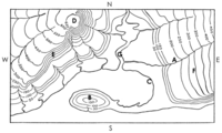
What is the contour interval on this map?
(a)
2.
FILL IN THE BLANKS QUESTION
2 mins • 1 pt
What letter represents the highest point on this map?
(a)
3.
MULTIPLE CHOICE QUESTION
2 mins • 1 pt
What landform is represented at letter B?
hill
mountain
sinkhole
cliff
4.
MULTIPLE CHOICE QUESTION
2 mins • 1 pt
What direction is the river at point A flowing?
hill
mountain
sinkhole
cliff
Tags
NGSS.MS-ESS2-4
5.
MULTIPLE CHOICE QUESTION
2 mins • 1 pt
What do the V-shaped contour lines represent?
earth quake fault
river valley
hiking trail
lava flow
6.
MULTIPLE CHOICE QUESTION
2 mins • 1 pt
What letters represent the two hills?
A & B
D & F
B & D
E & A
7.
MULTIPLE CHOICE QUESTION
2 mins • 1 pt
What letters represent the two hills?
A & B
D & F
B & D
E & A
Access all questions and much more by creating a free account
Create resources
Host any resource
Get auto-graded reports
Continue with Google

Continue with Email
Continue with Microsoft
or continue with

%20(1).png)
Apple
Others
Already have an account?
