2.4 Topographic Maps
Authored by Jen FArrar
Science
6th Grade
NGSS covered
Used 9+ times

AI Actions
Add similar questions
Adjust reading levels
Convert to real-world scenario
Translate activity
More...
Content View
Student View
44 questions
Show all answers
1.
MULTIPLE CHOICE QUESTION
30 sec • 1 pt
test
1
2
3
4
Tags
NGSS.MS-PS1-2
2.
MULTIPLE CHOICE QUESTION
2 mins • 1 pt

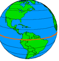
What is the name of this line at 0 degrees latitude?
3.
MULTIPLE CHOICE QUESTION
2 mins • 1 pt
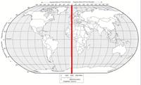
What is the name of the line at zero degrees longitude?
4.
MULTIPLE CHOICE QUESTION
2 mins • 1 pt

5.
MULTIPLE CHOICE QUESTION
2 mins • 1 pt
6.
MULTIPLE CHOICE QUESTION
3 mins • 1 pt

Which STATE is located at...
120°W, 45°N
7.
MULTIPLE CHOICE QUESTION
3 mins • 1 pt

Which STATE is located at...
105°W, 47°N


Access all questions and much more by creating a free account
Create resources
Host any resource
Get auto-graded reports
Continue with Google

Continue with Email
Continue with Classlink
Continue with Clever
or continue with
Microsoft
%20(1).png)
Apple
Others
Already have an account?
Similar Resources on Wayground

41 questions
Measurement and Conversions
Quiz
•
6th - 8th Grade
40 questions
Eukaryotic vs prokaryotic
Quiz
•
6th - 8th Grade
40 questions
6.4.3 Exam Review
Quiz
•
6th Grade
45 questions
Hazards & Precautions
Quiz
•
6th Grade
39 questions
Term 2 revision quizizz
Quiz
•
6th Grade
40 questions
Earth's Spheres
Quiz
•
4th - 6th Grade
47 questions
Estuaries in Virginia!
Quiz
•
6th - 8th Grade
40 questions
Science Skills
Quiz
•
6th Grade
Popular Resources on Wayground
15 questions
Fractions on a Number Line
Quiz
•
3rd Grade
10 questions
Probability Practice
Quiz
•
4th Grade
15 questions
Probability on Number LIne
Quiz
•
4th Grade
20 questions
Equivalent Fractions
Quiz
•
3rd Grade
25 questions
Multiplication Facts
Quiz
•
5th Grade
22 questions
fractions
Quiz
•
3rd Grade
6 questions
Appropriate Chromebook Usage
Lesson
•
7th Grade
10 questions
Greek Bases tele and phon
Quiz
•
6th - 8th Grade
Discover more resources for Science
20 questions
Rocks and The Rock Cycle
Quiz
•
6th Grade
10 questions
Exploring the Rock Cycle
Interactive video
•
6th - 8th Grade
8 questions
Newton's Second Law
Lesson
•
6th - 8th Grade
20 questions
Thermal Energy - Heat Transfer
Quiz
•
6th Grade
10 questions
Exploring the Rock Cycle: Types and Formation
Interactive video
•
6th - 8th Grade
25 questions
Evolution and Natural Selection Review
Quiz
•
6th - 8th Grade
22 questions
Layers of the Atmosphere
Quiz
•
6th Grade
15 questions
Punnett Squares
Quiz
•
6th Grade