
IL Mapping Test
Authored by Bryan Micklos
Social Studies
6th - 8th Grade
Used 7+ times


AI Actions
Add similar questions
Adjust reading levels
Convert to real-world scenario
Translate activity
More...
Content View
Student View
10 questions
Show all answers
1.
MULTIPLE CHOICE QUESTION
30 sec • 1 pt
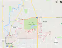
What geographic border runs to the west of Loves Park?
Interstate 90
Rock Cut State Park
Anderson Japanese Garden
Rock River
2.
MULTIPLE SELECT QUESTION
30 sec • 1 pt

Which states border Illinois? (Check all that apply)
Wisconsin
Iowa
Indiana
Missouri
Kentucky
3.
MULTIPLE CHOICE QUESTION
30 sec • 1 pt
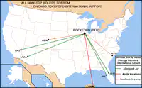
How many airlines fly nonstop to and from the Chicago Rockford International Airport?
6
3
2
1
4.
MULTIPLE CHOICE QUESTION
30 sec • 1 pt
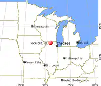
You would need to drive which direction to reach Chicago, if driving from Rockford?
North
South
SouthEast
NorthWest
5.
MULTIPLE CHOICE QUESTION
30 sec • 1 pt
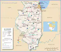
Which interstate travels through Illinois' capital?
55
57
90
70
6.
MULTIPLE CHOICE QUESTION
30 sec • 1 pt
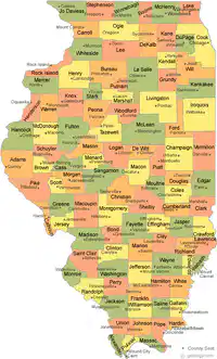
What county is Loves Park and Machesney Park located?
Boone County
Ford County
Ogle County
Winnebago County
7.
MULTIPLE CHOICE QUESTION
30 sec • 1 pt
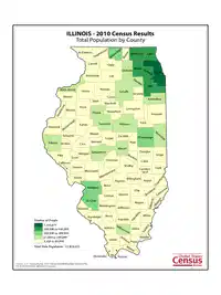
Which of the following counties has the densest population?
Cook
LaSalle
Madison
Winnebago
Access all questions and much more by creating a free account
Create resources
Host any resource
Get auto-graded reports

Continue with Google

Continue with Email

Continue with Microsoft
or continue with

%20(1).png)
Apple

Others
Already have an account?


