Exploring Map Skills and Navigation Techniques
Interactive Video
•
English
•
6th - 10th Grade
•
Practice Problem
•
Hard
+8
Standards-aligned

Lucas Foster
Used 2+ times
FREE Resource
Standards-aligned
Read more
10 questions
Show all answers
1.
MULTIPLE CHOICE QUESTION
30 sec • 1 pt
Why do maps use symbols instead of text to label features?
To save space on the map
To avoid clutter and make the map easier to understand
To make the map look more professional
To make the map look colorful
Tags
CCSS.RI.6.7
CCSS.RI.7.7
CCSS.RI.8.7
CCSS.RI.9-10.7
CCSS.RL.9-10.7
2.
MULTIPLE CHOICE QUESTION
30 sec • 1 pt
What is a good method to learn map symbols?
Reading books
Watching videos
Listening to audio guides
Using flashcards
3.
MULTIPLE CHOICE QUESTION
30 sec • 1 pt
Which mnemonic helps remember the order of the cardinal points?
New Elephants Swim Well
North East South West
Never Eat Shredded Wheat
Naughty Elephants Squirt Water
Tags
CCSS.RF.3.3B
CCSS.RF.3.3C
CCSS.RF.3.3D
CCSS.RF.4.3A
CCSS.RF.5.3A
4.
MULTIPLE CHOICE QUESTION
30 sec • 1 pt
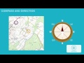
What is the direction of travel from West Deans to Spiral using an eight-point compass?
West
East
South
North
5.
MULTIPLE CHOICE QUESTION
30 sec • 1 pt
Which direction would you travel to go from Adressa to Western Deans?
South
North
West
East
6.
MULTIPLE CHOICE QUESTION
30 sec • 1 pt
What is the two-letter code for the Ordnance Survey map in the example?
SK
KK
KS
SS
7.
MULTIPLE CHOICE QUESTION
30 sec • 1 pt
How many kilometers across are the largest grid squares on an Ordnance Survey map?
10 km
50 km
100 km
200 km
Tags
CCSS.7.G.A.1
Access all questions and much more by creating a free account
Create resources
Host any resource
Get auto-graded reports
Continue with Google

Continue with Email
Continue with Classlink
Continue with Clever
or continue with
Microsoft
%20(1).png)
Apple
Others
Already have an account?
Popular Resources on Wayground

7 questions
History of Valentine's Day
Interactive video
•
4th Grade
15 questions
Fractions on a Number Line
Quiz
•
3rd Grade
20 questions
Equivalent Fractions
Quiz
•
3rd Grade
25 questions
Multiplication Facts
Quiz
•
5th Grade
22 questions
fractions
Quiz
•
3rd Grade
15 questions
Valentine's Day Trivia
Quiz
•
3rd Grade
20 questions
Main Idea and Details
Quiz
•
5th Grade
20 questions
Context Clues
Quiz
•
6th Grade
Discover more resources for English
20 questions
Context Clues
Quiz
•
6th Grade
10 questions
Exploring Valentine's Day with Charlie Brown
Interactive video
•
6th - 10th Grade
20 questions
Figurative Language Review
Quiz
•
6th Grade
25 questions
7th Reading STAAR Vocabulary
Quiz
•
6th - 8th Grade
20 questions
Revising & Editing practice
Quiz
•
7th Grade
20 questions
Main Idea and Supporting Details
Quiz
•
7th Grade
24 questions
7th grade STAAR Reading Review
Quiz
•
7th Grade
15 questions
Theme
Lesson
•
3rd - 7th Grade