Exploring Political and Physical Map Skills
Interactive Video
•
English
•
6th - 10th Grade
•
Practice Problem
•
Medium

Amelia Wright
Used 23+ times
FREE Resource
Read more
10 questions
Show all answers
1.
MULTIPLE CHOICE QUESTION
30 sec • 1 pt
What is a map?
A drawing of a place from high above
A list of places to visit
A book about geography
A photograph of a city
2.
MULTIPLE CHOICE QUESTION
30 sec • 1 pt
Why would you use a political map?
To locate major highways and cities
To find hiking trails
To find the best places to swim
To see the physical features of the land
3.
MULTIPLE CHOICE QUESTION
30 sec • 1 pt
What does a political map show?
Vegetation zones
Weather patterns
Streets, highways, and cities
Mountains and rivers
4.
MULTIPLE CHOICE QUESTION
30 sec • 1 pt
What is the purpose of the red lines on a political map?
To highlight water bodies
To mark state borders
To show major roads
To indicate hiking trails
5.
MULTIPLE CHOICE QUESTION
30 sec • 1 pt
What kind of map would you use to find mountains?
Political map
Road map
Weather map
Physical map
6.
MULTIPLE CHOICE QUESTION
30 sec • 1 pt
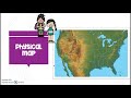
What does a physical map show?
Climate zones
Physical features of the earth
Political boundaries
Population density
7.
MULTIPLE CHOICE QUESTION
30 sec • 1 pt
Where would you likely go hiking according to a physical map?
Texas
Idaho
Florida
Louisiana
Access all questions and much more by creating a free account
Create resources
Host any resource
Get auto-graded reports
Continue with Google

Continue with Email
Continue with Classlink
Continue with Clever
or continue with
Microsoft
%20(1).png)
Apple
Others
Already have an account?
