Exploring Topo Gradient Concepts
Interactive Video
•
Science
•
6th - 10th Grade
•
Practice Problem
•
Hard

Olivia Brooks
FREE Resource
Read more
10 questions
Show all answers
1.
MULTIPLE CHOICE QUESTION
30 sec • 1 pt
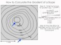
What is the first step in calculating the gradient on a topographic map?
Recording the gradient formula
Identifying the contour lines
Measuring the elevation of a point
Finding the distance between two points
2.
MULTIPLE CHOICE QUESTION
30 sec • 1 pt
Where can you find the formula for gradient in the reference tables?
Page 3
Page 1
Page 5
Page 2
3.
MULTIPLE CHOICE QUESTION
30 sec • 1 pt
What does the field value refer to in the context of a topographic map?
Distance
Elevation
Pressure
Temperature
4.
MULTIPLE CHOICE QUESTION
30 sec • 1 pt
What is the elevation of point Y?
400
300
380
320
5.
MULTIPLE CHOICE QUESTION
30 sec • 1 pt
How do you determine the contour interval on a topographic map?
By measuring the distance between two points
By checking the map scale
By identifying the difference in elevation between contour lines
By using a calculator
6.
MULTIPLE CHOICE QUESTION
30 sec • 1 pt
What is the elevation of point X?
380
400
360
300
7.
MULTIPLE CHOICE QUESTION
30 sec • 1 pt
How do you measure the distance between points X and Y?
Using a ruler
Using a compass
Using the map scale and scrap paper
Using a calculator
Access all questions and much more by creating a free account
Create resources
Host any resource
Get auto-graded reports
Continue with Google

Continue with Email
Continue with Classlink
Continue with Clever
or continue with
Microsoft
%20(1).png)
Apple
Others
Already have an account?
Similar Resources on Wayground

6 questions
INAAM READING COMPREHENSION REVIEW
Interactive video
•
KG
6 questions
Black Holes
Interactive video
•
6th - 12th Grade
6 questions
I WONDER - How Are The Planets Named? Me Pregunto - Cómo Se Nombran Los Planetas?
Interactive video
•
KG - 12th Grade
2 questions
MORE DANGEROUS than a Black Widow?!
Interactive video
•
6th - 9th Grade
Popular Resources on Wayground
15 questions
Fractions on a Number Line
Quiz
•
3rd Grade
20 questions
Equivalent Fractions
Quiz
•
3rd Grade
25 questions
Multiplication Facts
Quiz
•
5th Grade
22 questions
fractions
Quiz
•
3rd Grade
20 questions
Main Idea and Details
Quiz
•
5th Grade
20 questions
Context Clues
Quiz
•
6th Grade
15 questions
Equivalent Fractions
Quiz
•
4th Grade
20 questions
Figurative Language Review
Quiz
•
6th Grade
Discover more resources for Science
33 questions
Grade 6 Quarter 3 PMA 5 Review
Quiz
•
6th - 8th Grade
85 questions
Midpoint D1 Review
Quiz
•
8th Grade
20 questions
Rocks and The Rock Cycle
Quiz
•
6th Grade
12 questions
Ecological Succession
Quiz
•
7th Grade
12 questions
Newton's Laws of Motion
Lesson
•
6th - 8th Grade
10 questions
Exploring the Rock Cycle: Types and Formation
Interactive video
•
6th - 8th Grade
10 questions
Exploring the Layers of the Earth
Interactive video
•
6th - 10th Grade
20 questions
Pure Substances & Mixtures
Quiz
•
8th Grade