Exploring Different Types of Maps
Interactive Video
•
Social Studies
•
6th - 10th Grade
•
Practice Problem
•
Hard

Emma Peterson
FREE Resource
10 questions
Show all answers
1.
MULTIPLE CHOICE QUESTION
30 sec • 1 pt
What is the main purpose of learning about different types of maps in social studies?
To understand the history of map-making
To get information about the pegs
To learn about different cultures
To memorize country names
2.
MULTIPLE CHOICE QUESTION
30 sec • 1 pt
What do political maps primarily show?
Natural landforms
Population density
Human-made boundaries
Climate zones
3.
MULTIPLE CHOICE QUESTION
30 sec • 1 pt
Which of the following is NOT typically shown on a political map?
Rivers
Countries
Provinces
States
4.
MULTIPLE CHOICE QUESTION
30 sec • 1 pt
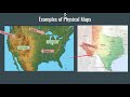
What do physical maps use to show elevation?
Symbols
Different colors
Numbers
Dotted lines
5.
MULTIPLE CHOICE QUESTION
30 sec • 1 pt
Which feature is commonly shown on physical maps but not on political maps?
Mountains
Country boundaries
Districts
State boundaries
6.
MULTIPLE CHOICE QUESTION
30 sec • 1 pt
What is a key characteristic of regional maps?
They show elevation
They can change over time
They show human-made boundaries
They have fixed boundaries
7.
MULTIPLE CHOICE QUESTION
30 sec • 1 pt
Which of the following is an example of a regional map?
A map showing the climate zones of the world
A map showing the population density of Texas
A map showing the counties of Texas
A map showing the regions of the United States
Access all questions and much more by creating a free account
Create resources
Host any resource
Get auto-graded reports
Continue with Google

Continue with Email
Continue with Classlink
Continue with Clever
or continue with
Microsoft
%20(1).png)
Apple
Others
Already have an account?
Popular Resources on Wayground

15 questions
Fractions on a Number Line
Quiz
•
3rd Grade
20 questions
Equivalent Fractions
Quiz
•
3rd Grade
25 questions
Multiplication Facts
Quiz
•
5th Grade
54 questions
Analyzing Line Graphs & Tables
Quiz
•
4th Grade
22 questions
fractions
Quiz
•
3rd Grade
20 questions
Main Idea and Details
Quiz
•
5th Grade
20 questions
Context Clues
Quiz
•
6th Grade
15 questions
Equivalent Fractions
Quiz
•
4th Grade
Discover more resources for Social Studies
38 questions
The Patriot Way: Classroom, Hallway, and Commons
Quiz
•
7th Grade
24 questions
Republic of Texas and Early Statehood Test Review
Quiz
•
7th Grade
35 questions
WH-Units 7 & 8 Test Review
Quiz
•
10th Grade
24 questions
Quiz #2- American Revolution
Quiz
•
7th Grade
24 questions
Republic of Texas Review
Quiz
•
7th Grade
17 questions
Early Statehood Review-3.0
Quiz
•
7th Grade
8 questions
Agriculture, Laws, and Slavery in Early Texas
Lesson
•
6th - 8th Grade
5 questions
Legislative branch Reiew
Interactive video
•
7th Grade