Understanding the Influence of Google Maps on Global Borders
Interactive Video
•
Geography, History, Social Studies, Philosophy
•
10th - 12th Grade
•
Practice Problem
•
Hard

Sophia Harris
FREE Resource
Read more
10 questions
Show all answers
1.
MULTIPLE CHOICE QUESTION
30 sec • 1 pt
In the 2010 Nicaragua-Costa Rica dispute, which entity did Costa Rica approach first to resolve the issue?
Nicaragua
The United Nations
The World Court
2.
MULTIPLE CHOICE QUESTION
30 sec • 1 pt
What was a common practice during colonial times to claim territory from less powerful nations?
Re-drawing maps
Cultural assimilation
Negotiating treaties
Military invasion
3.
MULTIPLE CHOICE QUESTION
30 sec • 1 pt
How does Google Maps handle the disputed region of Arunachal Pradesh?
Does not show the region at all
Shows it as part of India globally
Shows it as part of China globally
Creates different maps for different regions
4.
MULTIPLE CHOICE QUESTION
30 sec • 1 pt
What was the reaction when Google accidentally switched the borders between India and China in 2007?
It was praised for accuracy
It led to a peaceful resolution
It caused outrage in both countries
It was ignored by both countries
5.
MULTIPLE CHOICE QUESTION
30 sec • 1 pt
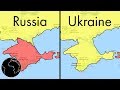
How quickly did Google Maps update the status of Crimea after Russian troops arrived in 2014?
Within a week
Within a month
Within a day
Within a year
6.
MULTIPLE CHOICE QUESTION
30 sec • 1 pt
What role did Google play in the mapping of South Sudan after its independence?
Google relied solely on UN maps
Google imposed its own borders
Google organized community mapping events
Google ignored the region
7.
MULTIPLE CHOICE QUESTION
30 sec • 1 pt
What is the purpose of Google's Map Maker program?
To create maps for military use
To allow anyone to edit country borders
To let users suggest changes for local maps
To replace all national maps
Access all questions and much more by creating a free account
Create resources
Host any resource
Get auto-graded reports
Continue with Google

Continue with Email
Continue with Classlink
Continue with Clever
or continue with
Microsoft
%20(1).png)
Apple
Others
Already have an account?
