Volcanology Map Interpretation
Interactive Video
•
Science, Geography
•
5th - 8th Grade
•
Practice Problem
•
Hard

Olivia Brooks
FREE Resource
Read more
9 questions
Show all answers
1.
MULTIPLE CHOICE QUESTION
30 sec • 1 pt
What does the Volcanology map primarily study?
Hurricanes
Tsunamis
Volcanoes
Earthquakes
2.
MULTIPLE CHOICE QUESTION
30 sec • 1 pt
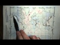
What do the red dots on the Volcanology map signify?
Active or historically active volcanoes
Meteor impact sites
Mountain peaks
Earthquake epicenters
3.
MULTIPLE CHOICE QUESTION
30 sec • 1 pt
What distinguishes the perfect circle red dots from the irregular ones on the map?
Irregular dots represent inactive volcanoes
Perfect circles represent visible volcanoes from the air
Irregular dots represent visible volcanoes from the air
Perfect circles represent underwater volcanoes
4.
MULTIPLE CHOICE QUESTION
30 sec • 1 pt
How are the irregular red dots on the map created?
With a computer program
With a stencil
With a pen
With a laser
5.
MULTIPLE CHOICE QUESTION
30 sec • 1 pt
Where are many volcanoes located according to the map?
Along the edges of continents and islands
In polar regions
In desert regions
In the middle of continents
6.
MULTIPLE CHOICE QUESTION
30 sec • 1 pt
What is a common misconception about the blue areas on the map?
They represent mountains
They represent deserts
They represent oceans
They represent forests
7.
MULTIPLE CHOICE QUESTION
30 sec • 1 pt
What do the blue areas on the map actually represent?
Lakes
Oceans
Continents
Rivers
Access all questions and much more by creating a free account
Create resources
Host any resource
Get auto-graded reports
Continue with Google

Continue with Email
Continue with Classlink
Continue with Clever
or continue with
Microsoft
%20(1).png)
Apple
Others
Already have an account?
Similar Resources on Wayground
Popular Resources on Wayground

7 questions
History of Valentine's Day
Interactive video
•
4th Grade
15 questions
Fractions on a Number Line
Quiz
•
3rd Grade
20 questions
Equivalent Fractions
Quiz
•
3rd Grade
25 questions
Multiplication Facts
Quiz
•
5th Grade
22 questions
fractions
Quiz
•
3rd Grade
15 questions
Valentine's Day Trivia
Quiz
•
3rd Grade
20 questions
Main Idea and Details
Quiz
•
5th Grade
20 questions
Context Clues
Quiz
•
6th Grade
Discover more resources for Science
11 questions
Valentines Day
Quiz
•
6th - 8th Grade
25 questions
Valentine's Day Trivia
Quiz
•
8th Grade
20 questions
Cell Organelles and Functions
Quiz
•
6th - 8th Grade
20 questions
Rocks and The Rock Cycle
Quiz
•
6th Grade
20 questions
Weathering, Erosion, Deposition
Quiz
•
5th Grade
20 questions
Food Chains and Food Webs Review
Quiz
•
5th Grade
28 questions
4th Grade The Need for Speed
Quiz
•
3rd - 5th Grade
8 questions
Newton's Second Law
Lesson
•
6th - 8th Grade