Exploring Topographic Maps and Their Features
Interactive Video
•
Science
•
6th - 10th Grade
•
Practice Problem
•
Hard
Standards-aligned

Aiden Montgomery
FREE Resource
Standards-aligned
Read more
10 questions
Show all answers
1.
MULTIPLE CHOICE QUESTION
30 sec • 1 pt
Why are topographic maps crucial for geographers and geography students?
They show political boundaries.
They are the foundation for many other geography skills.
They provide weather information.
They are used for navigation in cities.
2.
MULTIPLE CHOICE QUESTION
30 sec • 1 pt
What is the main problem that topographic maps solve?
Mapping the political boundaries.
Representing a three-dimensional world on a two-dimensional map.
Showing the population density of an area.
Indicating the climate zones.
3.
MULTIPLE CHOICE QUESTION
30 sec • 1 pt
How do geographers measure the height of a mountain for a topographic map?
Using drones to capture the height.
Using satellite images.
By walking around and measuring different heights above sea level.
By estimating based on nearby mountains.
4.
MULTIPLE CHOICE QUESTION
30 sec • 1 pt
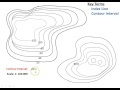
What is a contour line?
A line that shows the direction of the wind.
A line that shows the depth of the ocean.
A line that indicates the boundary between two countries.
A line that represents a constant elevation above sea level.
5.
MULTIPLE CHOICE QUESTION
30 sec • 1 pt
What is a contour interval?
The distance between two points on a map.
The difference in elevation between two contour lines.
The time taken to travel between two points.
The angle between two lines of sight.
6.
MULTIPLE CHOICE QUESTION
30 sec • 1 pt
What should you always check first when looking at a topographic map?
The date the map was created.
The color of the map.
The contour interval.
The scale of the map.
7.
MULTIPLE CHOICE QUESTION
30 sec • 1 pt
Why is there often a river at the bottom of a mountain?
Because of the high population density.
Due to the flat terrain.
Because of the presence of forests.
Due to gravity pulling water down the slopes.
Tags
NGSS.MS-ESS2-4
Access all questions and much more by creating a free account
Create resources
Host any resource
Get auto-graded reports
Continue with Google

Continue with Email
Continue with Classlink
Continue with Clever
or continue with
Microsoft
%20(1).png)
Apple
Others
Already have an account?
Popular Resources on Wayground

15 questions
Fractions on a Number Line
Quiz
•
3rd Grade
20 questions
Equivalent Fractions
Quiz
•
3rd Grade
25 questions
Multiplication Facts
Quiz
•
5th Grade
29 questions
Alg. 1 Section 5.1 Coordinate Plane
Quiz
•
9th Grade
22 questions
fractions
Quiz
•
3rd Grade
11 questions
FOREST Effective communication
Lesson
•
KG
20 questions
Main Idea and Details
Quiz
•
5th Grade
20 questions
Context Clues
Quiz
•
6th Grade
Discover more resources for Science
22 questions
Phases of the moon
Quiz
•
8th Grade
20 questions
Rocks and The Rock Cycle
Quiz
•
6th Grade
15 questions
Rock Cycle
Quiz
•
6th Grade
10 questions
Exploring the Rock Cycle
Interactive video
•
6th - 8th Grade
20 questions
Flow of Energy
Quiz
•
7th Grade
12 questions
Ecological Succession
Quiz
•
7th Grade
20 questions
Waves and Wave Properties
Quiz
•
6th - 8th Grade
8 questions
Amoeba Sister Asexual vs Sexual Reproduction
Interactive video
•
8th Grade