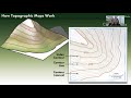
Navigating Topographic Maps and Contour Lines
Interactive Video
•
Science
•
6th - 10th Grade
•
Practice Problem
•
Medium
Standards-aligned

Jackson Turner
Used 28+ times
FREE Resource
Standards-aligned
Read more
10 questions
Show all answers
1.
MULTIPLE CHOICE QUESTION
30 sec • 1 pt
What natural process has significantly shaped the Grand Canyon?
Glacial movement
Volcanic activity
Earthquakes
Weathering and erosion by the Colorado River
Tags
NGSS.MS-ESS2-2
NGSS.MS-ESS2-4
2.
MULTIPLE CHOICE QUESTION
30 sec • 1 pt
What is the primary purpose of a topographic map?
To display weather patterns
To indicate population density
To represent changes in elevation
To show political boundaries
3.
MULTIPLE CHOICE QUESTION
30 sec • 1 pt
What do closely spaced contour lines on a topographic map indicate?
A valley
A steep slope
A river
A flat area
4.
MULTIPLE CHOICE QUESTION
30 sec • 1 pt
Which of the following is NOT a rule of contour lines?
Every point on a contour line has the same elevation
Contour lines never cross each other
Contour lines always connect with themselves
Contour lines can split or branch off
5.
MULTIPLE CHOICE QUESTION
30 sec • 1 pt
What is a contour interval?
The horizontal distance between two contour lines
The elevation change between two contour lines
The distance between two points on a map
The total elevation of a mountain
6.
MULTIPLE CHOICE QUESTION
30 sec • 1 pt
How do you calculate the contour interval?
By measuring the distance between two points
By subtracting the elevations of two index contours and dividing by the number of lines between them
By counting the number of contour lines on the map
By adding the elevations of two index contours
7.
MULTIPLE CHOICE QUESTION
30 sec • 1 pt
If the elevation difference between two index contours is 200 feet and there are 10 contour lines between them, what is the contour interval?
10 feet
40 feet
30 feet
20 feet
Access all questions and much more by creating a free account
Create resources
Host any resource
Get auto-graded reports
Continue with Google

Continue with Email
Continue with Microsoft
or continue with

%20(1).png)
Apple
Others
Already have an account?
