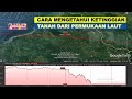
Understanding Elevation Measurement Using Google Earth
Interactive Video
•
Geography, Computers
•
5th - 8th Grade
•
Practice Problem
•
Easy

Mia Campbell
Used 1+ times
FREE Resource
Read more
10 questions
Show all answers
1.
MULTIPLE CHOICE QUESTION
30 sec • 1 pt
What is the main topic discussed in the video?
Building a computer
How to cook a traditional dish
Learning a new language
Measuring land elevation using Google Earth
2.
MULTIPLE CHOICE QUESTION
30 sec • 1 pt
What is the first step before using Google Earth for elevation measurement?
Connecting to the internet
Buying a new computer
Installing a new browser
Creating a new email account
3.
MULTIPLE CHOICE QUESTION
30 sec • 1 pt
Which tool is used in Google Earth to measure the distance to the sea?
Protractor
Ruler
Calculator
Compass
4.
MULTIPLE CHOICE QUESTION
30 sec • 1 pt
What should you do after selecting the area to measure in Google Earth?
Download the map
Change the map style
Zoom in on the area
Close the application
5.
MULTIPLE CHOICE QUESTION
30 sec • 1 pt
How can you view the elevation profile in Google Earth?
By pressing 'Elevation Chart'
By selecting 'Show Elevation Profile'
By choosing 'Display Height'
By clicking 'View Elevation'
6.
MULTIPLE CHOICE QUESTION
30 sec • 1 pt
What does the zero meter mark represent in the elevation profile?
The height of a building
The elevation from sea level
The depth of the ocean
The height of a mountain
7.
MULTIPLE CHOICE QUESTION
30 sec • 1 pt
What is the elevation of the first measured point in the example?
30 meters
1736 meters
1431 meters
728 meters
Access all questions and much more by creating a free account
Create resources
Host any resource
Get auto-graded reports
Continue with Google

Continue with Email
Continue with Classlink
Continue with Clever
or continue with
Microsoft
%20(1).png)
Apple
Others
Already have an account?
