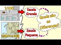
Understanding Cartographic Scales
Interactive Video
•
Geography
•
7th - 12th Grade
•
Practice Problem
•
Hard

Sophia Harris
FREE Resource
Read more
10 questions
Show all answers
1.
MULTIPLE CHOICE QUESTION
30 sec • 1 pt
What is the primary concept behind cartographic scales?
Increasing map size
Expansion of areas
Reduction of areas
Color coding of maps
2.
MULTIPLE CHOICE QUESTION
30 sec • 1 pt
Which scale is considered small?
1 to 500,000
1 to 1,000
1 to 10,000
1 to 25,000
3.
MULTIPLE CHOICE QUESTION
30 sec • 1 pt
Why might a large scale be used for a map?
To make the map easier to read
To reduce the cost of map production
To provide more detail for a smaller area
To cover a large area with less detail
4.
MULTIPLE CHOICE QUESTION
30 sec • 1 pt
What is a common use for small scales?
House plans
Blueprints
Country maps
City maps
5.
MULTIPLE CHOICE QUESTION
30 sec • 1 pt
What is the relationship between the denominator in a scale and the level of detail?
Direct relationship
No relationship
Random relationship
Inverse relationship
6.
MULTIPLE CHOICE QUESTION
30 sec • 1 pt
What does a scale of 1 to 500,000 typically represent?
Detailed city maps
Administrative boundaries
Blueprints
House plans
7.
MULTIPLE CHOICE QUESTION
30 sec • 1 pt
Which scale range is typically used for medium reductions?
1 to 1,000
1 to 25,000 to 1 to 250,000
1 to 10,000
1 to 500,000 and above
Access all questions and much more by creating a free account
Create resources
Host any resource
Get auto-graded reports
Continue with Google

Continue with Email
Continue with Microsoft
or continue with

%20(1).png)
Apple
Others
Already have an account?
