Boulders and the Money Pit Theory
Interactive Video
•
Science, Geography, History
•
9th - 12th Grade
•
Practice Problem
•
Hard

Lucas Foster
FREE Resource
Read more
10 questions
Show all answers
1.
MULTIPLE CHOICE QUESTION
30 sec • 1 pt
What is the main focus of Aaron Helton's theory presented to the Oak Island team?
Using a 14th-century map to locate the Money Pit
Building a new vault on Oak Island
Exploring the history of the Templars
Finding new drilling techniques
2.
MULTIPLE CHOICE QUESTION
30 sec • 1 pt
What publication featured the map that Aaron Helton found significant?
Time Magazine
National Geographic
Popular Science
Scientific American
3.
MULTIPLE CHOICE QUESTION
30 sec • 1 pt
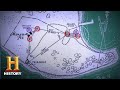
What is the purpose of the boulders and anchor points on the map?
To show ancient settlements
To indicate water sources
To triangulate the Money Pit's location
To mark historical sites
4.
MULTIPLE CHOICE QUESTION
30 sec • 1 pt
Which boulder is located along the east side of the swamp?
18a
15a
16a
20a
5.
MULTIPLE CHOICE QUESTION
30 sec • 1 pt
What is the significance of the intersection of lines drawn from the boulders?
It indicates the location of the Money Pit
It marks the location of a new dig site
It shows the boundary of Oak Island
It highlights a new treasure map
6.
MULTIPLE CHOICE QUESTION
30 sec • 1 pt
What was found during the excavation of the RF1 shaft?
Ancient artifacts
A hidden vault
Incredible evidence suggesting proximity to the original Money Pit
A new map
7.
MULTIPLE CHOICE QUESTION
30 sec • 1 pt
What does Aaron Helton use as a baseline for her theory?
A modern satellite image
Xena Halpern's believed 14th-century map
A geological survey
A historical document
Access all questions and much more by creating a free account
Create resources
Host any resource
Get auto-graded reports
Continue with Google

Continue with Email
Continue with Classlink
Continue with Clever
or continue with
Microsoft
%20(1).png)
Apple
Others
Already have an account?
