Mapping Ocean Depths and Features
Interactive Video
•
Science, Geography, Other
•
5th - 6th Grade
•
Practice Problem
•
Hard

Patricia Brown
FREE Resource
Read more
10 questions
Show all answers
1.
MULTIPLE CHOICE QUESTION
30 sec • 1 pt
What is the primary tool used by scientists to map the ocean floor?
Radar
Sonar
Lidar
Infrared
2.
MULTIPLE CHOICE QUESTION
30 sec • 1 pt
Which part of the ocean floor is closest to the beach?
Mid-ocean ridge
Continental shelf
Abyssal plain
Continental rise
3.
MULTIPLE CHOICE QUESTION
30 sec • 1 pt
What is the main function of the continental rise?
To form mountains
To collect sediment
To create valleys
To support marine life
4.
MULTIPLE CHOICE QUESTION
30 sec • 1 pt
What is the flat part of the ocean floor called?
Oceanic trench
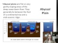
Seamount
Abyssal plain
Continental slope
5.
MULTIPLE CHOICE QUESTION
30 sec • 1 pt
Where are rift valleys typically found?
At the continental rise
In oceanic trenches
On seamounts
At mid-ocean ridges
6.
MULTIPLE CHOICE QUESTION
30 sec • 1 pt
What is the longest underwater mountain chain called?
Oceanic trench
Seamount
Mid-ocean ridge
Continental rise
7.
MULTIPLE CHOICE QUESTION
30 sec • 1 pt
What causes the formation of oceanic trenches?
Erosion
Transform faults
Convergent plate boundaries
Divergent plate boundaries
Access all questions and much more by creating a free account
Create resources
Host any resource
Get auto-graded reports
Continue with Google

Continue with Email
Continue with Classlink
Continue with Clever
or continue with
Microsoft
%20(1).png)
Apple
Others
Already have an account?
