Mapping Our World: Physical vs Political Maps
Interactive Video
•
Social Studies, Geography
•
2nd - 3rd Grade
•
Practice Problem
•
Hard

Patricia Brown
FREE Resource
Read more
10 questions
Show all answers
1.
MULTIPLE CHOICE QUESTION
30 sec • 1 pt
What is the main objective of the lesson on maps?
To learn about different types of maps
To understand the history of maps
To identify major cities on a map
To explain the difference between physical and political maps
2.
MULTIPLE CHOICE QUESTION
30 sec • 1 pt
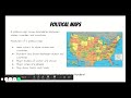
Which feature is NOT typically shown on a political map?
Country borders
Major cities
Mountain ranges
State boundaries
3.
MULTIPLE CHOICE QUESTION
30 sec • 1 pt
Which city is the capital of Tennessee as shown on the political map?
Memphis
Chattanooga
Knoxville
Nashville
4.
MULTIPLE CHOICE QUESTION
30 sec • 1 pt
What type of map would you use to find the boundary between two countries?
Weather map
Resource map
Political map
Physical map
5.
MULTIPLE CHOICE QUESTION
30 sec • 1 pt
What do the colors on a physical map represent?
Weather patterns
Types of land and elevation
Different countries
Political boundaries
6.
MULTIPLE CHOICE QUESTION
30 sec • 1 pt
Which of the following is a feature of physical maps?
Labeling major cities
Showing political boundaries
Indicating population density
Displaying landforms and bodies of water
7.
MULTIPLE CHOICE QUESTION
30 sec • 1 pt
What is the highest point in Tennessee according to the physical map?
Nashville
Great Smoky Mountains
Clingmans Dome
Mississippi River
Access all questions and much more by creating a free account
Create resources
Host any resource
Get auto-graded reports
Continue with Google

Continue with Email
Continue with Classlink
Continue with Clever
or continue with
Microsoft
%20(1).png)
Apple
Others
Already have an account?
