Geological Concepts and Evidence Analysis
Interactive Video
•
Science, Geography, History
•
9th - 10th Grade
•
Practice Problem
•
Hard

Patricia Brown
FREE Resource
Read more
10 questions
Show all answers
1.
MULTIPLE CHOICE QUESTION
30 sec • 1 pt
What is the primary focus of the initial step in the lesson on the Jalisco Block?
Introducing the geographical location of the Jalisco Block
Learning about the history of Mexico
Understanding the local culture of Guadalajara
Discussing the climate of Jalisco
2.
MULTIPLE CHOICE QUESTION
30 sec • 1 pt
Which tectonic plates converge near the Jalisco Block?
Australian, Philippine, and Pacific plates
Eurasian, African, and Indian plates
South American, Nazca, and Antarctic plates
North American, Riviera, Pacific, and Cocos plates
3.
MULTIPLE CHOICE QUESTION
30 sec • 1 pt
Why is it challenging to measure the movement of tectonic plates using GPS data?
The plates move in unpredictable patterns
GPS technology is not available in Mexico
The plates move too quickly for GPS to track
The movement is too slow, often just millimeters per year
4.
MULTIPLE CHOICE QUESTION
30 sec • 1 pt
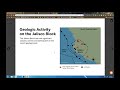
What is the significance of triangles and circles in the geological projections?
They are used to mark cities and towns
Triangles represent earthquake activity, circles represent volcanic activity
Triangles represent volcanic activity, circles represent earthquake activity
Both represent tectonic plate boundaries
5.
MULTIPLE CHOICE QUESTION
30 sec • 1 pt
What is the purpose of using evidence cards in the lesson?
To serve as a quiz for students
To help students memorize geological terms
To create a visual representation of the Jalisco Block
To facilitate discussion and categorization of geological evidence
6.
MULTIPLE CHOICE QUESTION
30 sec • 1 pt
What are the two types of boundaries students need to categorize evidence under?
Transform and static boundaries
Convergent and divergent boundaries
Erosional and depositional boundaries
Subduction and collision boundaries
7.
MULTIPLE CHOICE QUESTION
30 sec • 1 pt
What is encouraged during the sorting of evidence cards?
Only discussing with the teacher
Using only digital tools for sorting
Ignoring any conflicting evidence
Annotating or writing reasoning on the cards
Access all questions and much more by creating a free account
Create resources
Host any resource
Get auto-graded reports
Continue with Google

Continue with Email
Continue with Classlink
Continue with Clever
or continue with
Microsoft
%20(1).png)
Apple
Others
Already have an account?
