Understanding Weather Maps and Indicators
Interactive Video
•
Science, Geography, Physics
•
6th - 7th Grade
•
Practice Problem
•
Medium

Patricia Brown
Used 3+ times
FREE Resource
Read more
10 questions
Show all answers
1.
MULTIPLE CHOICE QUESTION
30 sec • 1 pt
What do the roots 'therm' and 'bar' refer to in the context of weather instruments?
Sunshine and visibility
Rainfall and cloud cover
Wind speed and humidity
Temperature and air pressure
2.
MULTIPLE CHOICE QUESTION
30 sec • 1 pt
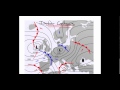
What do isobars on a weather map connect?
Areas with the same humidity
Areas with the same air pressure
Areas with the same temperature
Areas with the same wind speed
3.
MULTIPLE CHOICE QUESTION
30 sec • 1 pt
What do isotherms on a weather map indicate?
Regions with the same air pressure
Regions with the same temperature
Regions with the same precipitation
Regions with the same wind direction
4.
MULTIPLE CHOICE QUESTION
30 sec • 1 pt
How do isobar contours help in understanding weather patterns?
By highlighting humidity levels
By showing temperature variations
By indicating air pressure changes
By displaying wind speed
5.
MULTIPLE CHOICE QUESTION
30 sec • 1 pt
What happens to air pressure as you move towards the center of a low-pressure air mass?
It remains constant
It fluctuates
It decreases
It increases
6.
MULTIPLE CHOICE QUESTION
30 sec • 1 pt
What characteristic of isobars helps in identifying high-pressure air masses?
Rising air pressure readings
Decreasing temperature readings
Constant humidity levels
Fluctuating wind speeds
7.
MULTIPLE CHOICE QUESTION
30 sec • 1 pt
What do isotherm lines on a map generally show?
Wind speed changes
Air pressure variations
Temperature recordings
Humidity levels
Access all questions and much more by creating a free account
Create resources
Host any resource
Get auto-graded reports
Continue with Google

Continue with Email
Continue with Microsoft
or continue with

%20(1).png)
Apple
Others
Already have an account?
