Connecting Civilizations on a Map
Interactive Video
•
Geography, History, Social Studies
•
6th - 8th Grade
•
Practice Problem
•
Hard

Patricia Brown
FREE Resource
Read more
8 questions
Show all answers
1.
MULTIPLE CHOICE QUESTION
30 sec • 1 pt
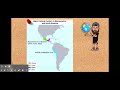
What tool is used to connect points on a map in the lesson?
Stickers
Markers
Thumbtacks and lines
Pins and strings
2.
MULTIPLE CHOICE QUESTION
30 sec • 1 pt
Which civilization is identified as the oldest among the four discussed?
Mayan
Inca
Aztec
Olmec
3.
MULTIPLE CHOICE QUESTION
30 sec • 1 pt
Where does the Mayan civilization rank in terms of age among the four discussed?
Oldest
Second oldest
Third oldest
Newest
4.
MULTIPLE CHOICE QUESTION
30 sec • 1 pt
What is the purpose of creating lines on the map in this lesson?
To connect different civilizations
To decorate the map
To mark territories
To highlight trade routes
5.
MULTIPLE CHOICE QUESTION
30 sec • 1 pt
What customization options are available for the lines on the map?
Color and thickness
Length and width
Shape and pattern
Material and texture
6.
MULTIPLE CHOICE QUESTION
30 sec • 1 pt
Which civilization's location has already been connected for the students?
Inca
Olmec
Mayan
Aztec
7.
MULTIPLE CHOICE QUESTION
30 sec • 1 pt
What should students do after connecting the civilizations on the map?
Add more civilizations
Erase the lines
Submit their work
Color the map
Access all questions and much more by creating a free account
Create resources
Host any resource
Get auto-graded reports
Continue with Google

Continue with Email
Continue with Microsoft
or continue with

%20(1).png)
Apple
Others
Already have an account?
