Map Projections and Geographic Concepts
Interactive Video
•
Geography, History, Social Studies
•
6th - 8th Grade
•
Practice Problem
•
Hard

Patricia Brown
FREE Resource
Read more
10 questions
Show all answers
1.
MULTIPLE CHOICE QUESTION
30 sec • 1 pt
What is the primary focus of geographers when studying the Earth?
The cultural practices of different societies
The economic development of countries
The history of human civilizations
The impact of the Earth on people and vice versa
2.
MULTIPLE CHOICE QUESTION
30 sec • 1 pt
In which sectors do geographers typically work?
Retail and marketing
Government and private industry
Education and healthcare
Entertainment and media
3.
MULTIPLE CHOICE QUESTION
30 sec • 1 pt
Why are maps considered more useful than globes in many cases?
They do not distort land sizes
They are easier to carry and use
They provide a 3D view of the Earth
They are more accurate
4.
MULTIPLE CHOICE QUESTION
30 sec • 1 pt
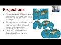
Which map projection is known for making Greenland appear much larger than it is?
Mercator projection
Robinson projection
Goods Interrupted projection
Peters projection
5.
MULTIPLE CHOICE QUESTION
30 sec • 1 pt
What is a major flaw of all map projections?
They do not show political boundaries
They are difficult to read
They misrepresent the size and shape of land masses
They are too expensive to produce
6.
MULTIPLE CHOICE QUESTION
30 sec • 1 pt
Which projection attempts to reduce the size distortion of Greenland and Antarctica?
Peters projection
Goods Interrupted projection
Robinson projection
Mercator projection
7.
MULTIPLE CHOICE QUESTION
30 sec • 1 pt
What do lines of latitude indicate?
Elevation above sea level
Depth below sea level
Distance from the Equator
Distance from the Prime Meridian
Access all questions and much more by creating a free account
Create resources
Host any resource
Get auto-graded reports
Continue with Google

Continue with Email
Continue with Microsoft
or continue with

%20(1).png)
Apple
Others
Already have an account?
