Topographic Maps and Elevation Concepts
Interactive Video
•
Geography, Science, Mathematics
•
6th - 7th Grade
•
Practice Problem
•
Hard

Patricia Brown
FREE Resource
Read more
10 questions
Show all answers
1.
MULTIPLE CHOICE QUESTION
30 sec • 1 pt
What does a topographic map primarily show?
The types of vegetation
The population density
The shape and elevation of land features
The climate of a region
2.
MULTIPLE CHOICE QUESTION
30 sec • 1 pt
What is a contour line?
A line that marks the boundary of a country
A line that indicates the temperature
A line that connects points of equal elevation
A line that shows the direction of the wind
3.
MULTIPLE CHOICE QUESTION
30 sec • 1 pt
Why is it suggested to have the map and questions on the same page?
To ensure the map is not lost
To make the notebook look neat
To avoid flipping pages while answering questions
To save paper
4.
MULTIPLE CHOICE QUESTION
30 sec • 1 pt
What should you do if a contour line on a map is not labeled?
Ignore it
Estimate its elevation based on nearby labeled lines
Draw a new line
Erase it
5.
MULTIPLE CHOICE QUESTION
30 sec • 1 pt
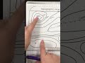
What is the elevation at position B if the contour interval is 10 meters and the nearest labeled line is 500 meters?
550 meters
530 meters
520 meters
510 meters
6.
MULTIPLE CHOICE QUESTION
30 sec • 1 pt
How do you determine the contour interval on a map?
By counting the number of lines
By measuring the distance between lines
By checking the map legend
By finding the difference in elevation between two labeled lines
7.
MULTIPLE CHOICE QUESTION
30 sec • 1 pt
Which position has a higher elevation, C or D, if C is at 560 meters and D is at 550 meters?
Both are the same
Position D
Position C
Cannot be determined
Access all questions and much more by creating a free account
Create resources
Host any resource
Get auto-graded reports
Continue with Google

Continue with Email
Continue with Classlink
Continue with Clever
or continue with
Microsoft
%20(1).png)
Apple
Others
Already have an account?
Similar Resources on Wayground

11 questions
Understanding Multiplication and Properties
Interactive video
•
5th - 8th Grade
11 questions
Exploring Florida and Beyond
Interactive video
•
5th - 8th Grade
6 questions
Boris Johnson gets on his bike in Beeston
Interactive video
•
6th - 8th Grade
11 questions
Statistics and Geometry Concepts
Interactive video
•
6th - 7th Grade
8 questions
Mussel Harvesting in Ireland
Interactive video
•
5th - 8th Grade
6 questions
UK Cabinet Meeting Ahead of Brexit
Interactive video
•
6th - 7th Grade
6 questions
NHS Nightingale Hospital Harrogate Interiors
Interactive video
•
6th - 7th Grade
6 questions
CLEAN : Haiti votes for new president amid security concerns 2
Interactive video
•
6th - 7th Grade
Popular Resources on Wayground
7 questions
History of Valentine's Day
Interactive video
•
4th Grade
15 questions
Fractions on a Number Line
Quiz
•
3rd Grade
20 questions
Equivalent Fractions
Quiz
•
3rd Grade
25 questions
Multiplication Facts
Quiz
•
5th Grade
22 questions
fractions
Quiz
•
3rd Grade
15 questions
Valentine's Day Trivia
Quiz
•
3rd Grade
20 questions
Main Idea and Details
Quiz
•
5th Grade
20 questions
Context Clues
Quiz
•
6th Grade
Discover more resources for Geography
21 questions
Continents and Oceans
Quiz
•
6th Grade
10 questions
Seasons and Earth's Tilt
Quiz
•
7th Grade
12 questions
Russia, Central Asia, & the Caucasus
Quiz
•
6th Grade
20 questions
Mardi Gras History
Quiz
•
6th Grade - University
16 questions
Southern and Eastern Asia Government Basics
Quiz
•
7th Grade
21 questions
Plate Tectonics and Earth's Structure review quiz
Quiz
•
6th Grade
10 questions
38a, b, c: Voluntary trade in Africa
Quiz
•
7th Grade
10 questions
Understanding Landslides
Interactive video
•
5th - 6th Grade