Plate Boundaries and Earthquake Relationships
Interactive Video
•
Science, Geography, Physics
•
6th - 8th Grade
•
Practice Problem
•
Hard

Patricia Brown
FREE Resource
Read more
10 questions
Show all answers
1.
MULTIPLE CHOICE QUESTION
30 sec • 1 pt
What are the two initial claims discussed in the lesson regarding plate movement and earthquakes?
Plates move due to ocean currents, or ocean currents cause plates to move.
Earthquakes are caused by weather changes, or weather changes cause earthquakes.
Plates move due to volcanic activity, or volcanic activity causes plates to move.
Plates move causing earthquakes, or earthquakes cause plates to move.
2.
MULTIPLE CHOICE QUESTION
30 sec • 1 pt
What is the purpose of the simulation exercise in the lesson?
To study the impact of human activity on plate tectonics.
To observe the effects of weather on plate movement.
To analyze the role of ocean currents in plate movement.
To explore the relationship between plate movement and earthquakes.
3.
MULTIPLE CHOICE QUESTION
30 sec • 1 pt
What is the relationship between plate movement and earthquakes explored in the simulation?
Earthquakes cause plates to move.
Plates move due to ocean currents.
Plates move causing earthquakes.
Earthquakes are unrelated to plate movement.
4.
MULTIPLE CHOICE QUESTION
30 sec • 1 pt
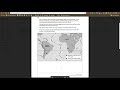
Which continents are focused on in the modeling of plate boundaries?
Antarctica and Asia
South America and Africa
Asia and Australia
North America and Europe
5.
MULTIPLE CHOICE QUESTION
30 sec • 1 pt
Why are meso source fossils significant in the study of plate boundaries?
They indicate the presence of ancient civilizations.
They provide evidence for the movement of continents.
They show the impact of climate change on plate tectonics.
They are used to predict future earthquakes.
6.
MULTIPLE CHOICE QUESTION
30 sec • 1 pt
What is the significance of the dashed line in the modeling handout?
It represents a river boundary.
It indicates a fault line.
It marks a volcanic zone.
It shows the cross-section location.
7.
MULTIPLE CHOICE QUESTION
30 sec • 1 pt
What is the task involving cross-sections in the lesson?
Drawing a cross-section of a mountain range.
Creating a cross-section of a river delta.
Drawing and comparing cross-sections of plate boundaries.
Designing a cross-section of a volcanic eruption.
Access all questions and much more by creating a free account
Create resources
Host any resource
Get auto-graded reports
Continue with Google

Continue with Email
Continue with Classlink
Continue with Clever
or continue with
Microsoft
%20(1).png)
Apple
Others
Already have an account?
