Geologic Cross-Section Techniques
Interactive Video
•
Science, Geography, Other
•
9th - 12th Grade
•
Practice Problem
•
Hard

Patricia Brown
FREE Resource
Read more
10 questions
Show all answers
1.
MULTIPLE CHOICE QUESTION
30 sec • 1 pt
What is the primary purpose of a geologic cross-section?
To display the climate conditions of a region
To show the surface features of the earth
To provide a vertical slice through the earth revealing underlying structures
To map the distribution of vegetation
2.
MULTIPLE CHOICE QUESTION
30 sec • 1 pt
Which of the following rock types is NOT mentioned in the video?
Granite
Limestone
Sandstone
Shale
3.
MULTIPLE CHOICE QUESTION
30 sec • 1 pt
What does the long arm of the 'squished tee' symbol represent on a geologic map?
Erosion pattern
Rock type
Strike direction
Dip direction
4.
MULTIPLE CHOICE QUESTION
30 sec • 1 pt
In the context of geologic maps, what does 'dip' refer to?
The age of the rock layer
The color of the rock layer
The angle and direction a rock layer makes with the surface
The thickness of the rock layer
5.
MULTIPLE CHOICE QUESTION
30 sec • 1 pt
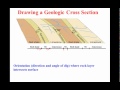
What is the first step in drawing a geologic cross-section?
Transferring rock type locations and names from the map
Drawing the final structure
Measuring the depth of rock layers
Calculating the age of the rocks
6.
MULTIPLE CHOICE QUESTION
30 sec • 1 pt
Why is it important to use a protractor when drawing dip angles?
To make the drawing process faster
To avoid using other drawing tools
To accurately represent the dip direction and angle
To ensure the angles are aesthetically pleasing
7.
MULTIPLE CHOICE QUESTION
30 sec • 1 pt
What is a common mistake students make when drawing cross-sections?
Drawing lines too straight
Ignoring the rock types
Projecting dip angles too far below the surface
Using too many colors
Access all questions and much more by creating a free account
Create resources
Host any resource
Get auto-graded reports
Continue with Google

Continue with Email
Continue with Classlink
Continue with Clever
or continue with
Microsoft
%20(1).png)
Apple
Others
Already have an account?
