Navigational Concepts and Techniques
Interactive Video
•
Geography, Science, Mathematics
•
6th - 8th Grade
•
Practice Problem
•
Hard

Patricia Brown
FREE Resource
Read more
10 questions
Show all answers
1.
MULTIPLE CHOICE QUESTION
30 sec • 1 pt
Why is latitude important in navigation?
It shows the altitude of a place.
It indicates the time zone of a location.
It measures the distance from the prime meridian.
It helps determine the distance from the equator.
2.
MULTIPLE CHOICE QUESTION
30 sec • 1 pt
What is the significance of the Tropic of Cancer?
It is the starting point for measuring longitude.
It marks the northernmost point where the sun can be directly overhead.
It is the line where the equator meets the prime meridian.
It is the southernmost point of the Arctic Circle.
3.
MULTIPLE CHOICE QUESTION
30 sec • 1 pt
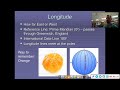
Which line is used as the reference for measuring longitude?
The Tropic of Capricorn
The Equator
The International Date Line
The Prime Meridian
4.
MULTIPLE CHOICE QUESTION
30 sec • 1 pt
How do longitude lines affect time zones?
They help in determining the time difference between locations.
They are used to calculate the distance from the equator.
They determine the altitude of a location.
They indicate the climate of a region.
5.
MULTIPLE CHOICE QUESTION
30 sec • 1 pt
What is the purpose of combining latitude and longitude?
To pinpoint a specific location on the globe.
To calculate the distance between two points.
To measure the altitude of a location.
To determine the climate of a region.
6.
MULTIPLE CHOICE QUESTION
30 sec • 1 pt
How can you remember the order of cardinal directions?
By following the path of the sun.
By memorizing the order of the planets.
By using a compass.
By using the phrase 'Never Eat Soggy Waffles'.
7.
MULTIPLE CHOICE QUESTION
30 sec • 1 pt
What is the Big Dipper used for in navigation?
To locate the North Star, Polaris.
To find the equator.
To determine the time of day.
To measure longitude.
Access all questions and much more by creating a free account
Create resources
Host any resource
Get auto-graded reports
Continue with Google

Continue with Email
Continue with Classlink
Continue with Clever
or continue with
Microsoft
%20(1).png)
Apple
Others
Already have an account?
