Understanding Latitude and Longitude Concepts
Interactive Video
•
Geography, History, Science
•
6th - 7th Grade
•
Practice Problem
•
Hard

Patricia Brown
FREE Resource
Read more
10 questions
Show all answers
1.
MULTIPLE CHOICE QUESTION
30 sec • 1 pt
What is the primary purpose of longitude and latitude lines on maps?
To measure the distance between two points
To locate places on Earth
To determine the climate of a location
To calculate the area of a region
2.
MULTIPLE CHOICE QUESTION
30 sec • 1 pt
Where do longitude lines originate from?
The north and south poles
The prime meridian
The Tropic of Cancer
The equator
3.
MULTIPLE CHOICE QUESTION
30 sec • 1 pt
How are lines of longitude labeled?
From 0 to 90 degrees
From 0 to 180 degrees
From 0 to 360 degrees
From 0 to 270 degrees
4.
MULTIPLE CHOICE QUESTION
30 sec • 1 pt
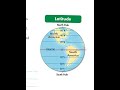
What is the starting point for latitude lines?
The equator
The Tropic of Capricorn
The prime meridian
The north pole
5.
MULTIPLE CHOICE QUESTION
30 sec • 1 pt
How are latitude lines north of the equator labeled?
With a W
With an N
With an E
With an S
6.
MULTIPLE CHOICE QUESTION
30 sec • 1 pt
Between which degrees of longitude does Indiana fall?
80 and 83 degrees west
85 and 88 degrees west
84 and 87 degrees west
90 and 93 degrees west
7.
MULTIPLE CHOICE QUESTION
30 sec • 1 pt
What is the range of latitude degrees for Indiana?
40 and 44 degrees north
34 and 38 degrees north
38 and 42 degrees north
36 and 40 degrees north
Access all questions and much more by creating a free account
Create resources
Host any resource
Get auto-graded reports
Continue with Google

Continue with Email
Continue with Microsoft
or continue with

%20(1).png)
Apple
Others
Already have an account?
