Understanding Maps and Their Features
Interactive Video
•
Geography, History, Social Studies
•
5th - 6th Grade
•
Practice Problem
•
Hard

Patricia Brown
FREE Resource
Read more
10 questions
Show all answers
1.
MULTIPLE CHOICE QUESTION
30 sec • 1 pt
What type of map is used to show the height of land above sea level?
Elevation map
Road map
Political map
Climate map
2.
MULTIPLE CHOICE QUESTION
30 sec • 1 pt
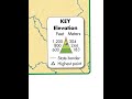
Which color on the elevation map indicates the highest elevation?
Green
Blue
Orange
Yellow
3.
MULTIPLE CHOICE QUESTION
30 sec • 1 pt
In which direction does Indiana's terrain generally slope?
From northwest to southeast
From southwest to northeast
From northeast to southwest
From southeast to northwest
4.
MULTIPLE CHOICE QUESTION
30 sec • 1 pt
What are the three regions of Indiana mentioned in the map?
Northern Lake and Moraine, Till Plains, Southern Hills and Lowland
Northern Plains, Central Valley, Southern Mountains
Eastern Highlands, Central Plains, Western Lowlands
Northern Hills, Central Basin, Southern Plateau
5.
MULTIPLE CHOICE QUESTION
30 sec • 1 pt
What is the purpose of a compass rose on a map?
To mark political boundaries
To display population
To indicate direction
To show elevation
6.
MULTIPLE CHOICE QUESTION
30 sec • 1 pt
What type of map shows destinations within an area, such as streets and points of interest?
Political map
Elevation map
Weather map
Topographic map
7.
MULTIPLE CHOICE QUESTION
30 sec • 1 pt
How are locations identified on a city map with a grid system?
By using color codes
By using compass directions
By using coordinates of rows and columns
By using elevation levels
Access all questions and much more by creating a free account
Create resources
Host any resource
Get auto-graded reports
Continue with Google

Continue with Email
Continue with Classlink
Continue with Clever
or continue with
Microsoft
%20(1).png)
Apple
Others
Already have an account?
Popular Resources on Wayground

7 questions
History of Valentine's Day
Interactive video
•
4th Grade
15 questions
Fractions on a Number Line
Quiz
•
3rd Grade
20 questions
Equivalent Fractions
Quiz
•
3rd Grade
25 questions
Multiplication Facts
Quiz
•
5th Grade
22 questions
fractions
Quiz
•
3rd Grade
15 questions
Valentine's Day Trivia
Quiz
•
3rd Grade
20 questions
Main Idea and Details
Quiz
•
5th Grade
20 questions
Context Clues
Quiz
•
6th Grade
Discover more resources for Geography
21 questions
Continents and Oceans
Quiz
•
6th Grade
12 questions
Russia, Central Asia, & the Caucasus
Quiz
•
6th Grade
20 questions
Mardi Gras History
Quiz
•
6th Grade - University
21 questions
Plate Tectonics and Earth's Structure review quiz
Quiz
•
6th Grade
10 questions
Understanding Landslides
Interactive video
•
5th - 6th Grade
50 questions
50 States and Capitals
Quiz
•
5th Grade
15 questions
The President's Important Jobs: Head of State and Chief Executive
Passage
•
5th Grade