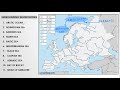
Mapping Water Bodies and Features
Interactive Video
•
Geography, Science, Social Studies
•
6th - 7th Grade
•
Practice Problem
•
Hard

Patricia Brown
FREE Resource
Read more
10 questions
Show all answers
1.
MULTIPLE CHOICE QUESTION
30 sec • 1 pt
What are the main features to be marked on the physical map of Europe?
Only rivers
Only mountains
Water bodies, rivers, and mountains
Only cities
2.
MULTIPLE CHOICE QUESTION
30 sec • 1 pt
What is a key characteristic of the river-marked maps discussed in the video?
They include city names
They have rivers already marked
They are only used in North America
They do not include any labels
3.
MULTIPLE CHOICE QUESTION
30 sec • 1 pt
Which color is recommended for marking water bodies on the map?
Green
Yellow
Red
Blue
4.
MULTIPLE CHOICE QUESTION
30 sec • 1 pt
What should you do if there is not enough space to write the name of a water body?
Skip marking it
Use a smaller font
Draw an arrow towards the feature
Write it on the land area
5.
MULTIPLE CHOICE QUESTION
30 sec • 1 pt
Which sea is located just below the Arctic Ocean?
Black Sea
Mediterranean Sea
Norwegian Sea
Baltic Sea
6.
MULTIPLE CHOICE QUESTION
30 sec • 1 pt
What is the correct way to label the Mediterranean Sea on the map?
Write it on the land area
Use a red pen
Use block letters
Write it in cursive
7.
MULTIPLE CHOICE QUESTION
30 sec • 1 pt
Which sea is known for having oil deposits?
Adriatic Sea
North Sea
Caspian Sea
Bay of Biscay
Access all questions and much more by creating a free account
Create resources
Host any resource
Get auto-graded reports
Continue with Google

Continue with Email
Continue with Classlink
Continue with Clever
or continue with
Microsoft
%20(1).png)
Apple
Others
Already have an account?
