Atlas Features and Historical Context
Interactive Video
•
Geography, History, Science
•
9th - 10th Grade
•
Practice Problem
•
Hard

Patricia Brown
FREE Resource
Read more
10 questions
Show all answers
1.
MULTIPLE CHOICE QUESTION
30 sec • 1 pt
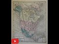
What is unique about the binding of the pre-Civil War American atlas?
It is made of leather.
It is embossed with gold.
It is made of recycled paper.
It is blind embossed cloth binding.
2.
MULTIPLE CHOICE QUESTION
30 sec • 1 pt
How many volumes was the pre-Civil War American atlas issued in?
One volume
Two volumes
Three volumes
Four volumes
3.
MULTIPLE CHOICE QUESTION
30 sec • 1 pt
What printing technique was used for the maps in the atlas?
Screen printing
Digital printing
Ceregraphy
Lithography
4.
MULTIPLE CHOICE QUESTION
30 sec • 1 pt
What is notable about the color of the maps in the atlas?
They are digitally colored.
They are hand-colored and original.
They are black and white.
They are colored with modern inks.
5.
MULTIPLE CHOICE QUESTION
30 sec • 1 pt
What is the condition of the atlas as described in the video?
Perfectly intact with no issues.
Slightly loose with minor annotations.
Completely damaged and unusable.
Newly restored and pristine.
6.
MULTIPLE CHOICE QUESTION
30 sec • 1 pt
What is the overall condition of the maps in the atlas?
They are newly printed.
They are missing from the atlas.
They are clean with minor soiling.
They are heavily damaged.
7.
MULTIPLE CHOICE QUESTION
30 sec • 1 pt
What impact did the Civil War have on atlas production?
Production was enhanced with new technology.
Production was curtailed due to shortages.
No impact on production.
Increased production due to high demand.
Access all questions and much more by creating a free account
Create resources
Host any resource
Get auto-graded reports
Continue with Google

Continue with Email
Continue with Classlink
Continue with Clever
or continue with
Microsoft
%20(1).png)
Apple
Others
Already have an account?
