Cross Sections and Intervisibility in Geography
Interactive Video
•
Geography
•
9th - 10th Grade
•
Practice Problem
•
Hard

Patricia Brown
FREE Resource
Read more
10 questions
Show all answers
1.
MULTIPLE CHOICE QUESTION
30 sec • 1 pt
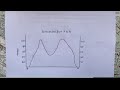
What is the primary purpose of learning about cross sections in geography?
To determine the population density of a city
To identify the climate zones of an area
To analyze the elevation changes across a landscape
To understand the political boundaries of a region
2.
MULTIPLE CHOICE QUESTION
30 sec • 1 pt
Which type of map is commonly used to draw cross sections?
Climate map
Road map
Political map
Topographic map
3.
MULTIPLE CHOICE QUESTION
30 sec • 1 pt
What tool is recommended for marking contour lines on a map?
A compass
A protractor
A paper strip
A magnifying glass
4.
MULTIPLE CHOICE QUESTION
30 sec • 1 pt
When plotting contour lines on a Cartesian plane, what is the typical interval used?
5 meters
10 meters
50 meters
20 meters
5.
MULTIPLE CHOICE QUESTION
30 sec • 1 pt
What is the first step in drawing a cross section from a map?
Identifying the highest point
Drawing a line from point A to B
Calculating the total distance
Measuring the temperature
6.
MULTIPLE CHOICE QUESTION
30 sec • 1 pt
What does the term 'intervisibility' refer to in map reading?
The ability to see across a flat surface
The visibility of a map in low light
The ability to see one point from another
The clarity of a map's print
7.
MULTIPLE CHOICE QUESTION
30 sec • 1 pt
If point X cannot see point Z due to an obstruction, what can be said about their intervisibility?
They are not intervisible
They are intervisible
They are completely visible
They are partially visible
Access all questions and much more by creating a free account
Create resources
Host any resource
Get auto-graded reports
Continue with Google

Continue with Email
Continue with Classlink
Continue with Clever
or continue with
Microsoft
%20(1).png)
Apple
Others
Already have an account?
