Topographic Maps and Water Flow
Interactive Video
•
Geography
•
6th - 7th Grade
•
Practice Problem
•
Hard

Patricia Brown
FREE Resource
Read more
10 questions
Show all answers
1.
MULTIPLE CHOICE QUESTION
30 sec • 1 pt
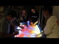
What is the primary purpose of an augmented reality topographic map?
To show population density
To represent terrain features and elevations
To display weather patterns
To visualize historical events
2.
MULTIPLE CHOICE QUESTION
30 sec • 1 pt
What do contour lines on a topographic map represent?
Temperature variations
Vegetation types
Elevation levels
Wind directions
3.
MULTIPLE CHOICE QUESTION
30 sec • 1 pt
What does it indicate when contour lines are close together on a map?
A plateau
A valley
A steep slope
A flat area
4.
MULTIPLE CHOICE QUESTION
30 sec • 1 pt
What kind of slope is indicated by contour lines that are far apart?
Steep slope
Gradual slope
Cliff
Ridge
5.
MULTIPLE CHOICE QUESTION
30 sec • 1 pt
In the hands-on activity, what does the color on the map indicate?
Soil type
Elevation
Vegetation
Temperature
6.
MULTIPLE CHOICE QUESTION
30 sec • 1 pt
What happens to water flow when it rains on the augmented reality map?
It stays still
It evaporates immediately
It follows the terrain
It flows uphill
7.
MULTIPLE CHOICE QUESTION
30 sec • 1 pt
What is the significance of the Continental Divide in terms of water flow?
It separates different climate zones
It divides the flow of rivers to different oceans
It marks the highest point in the country
It indicates tectonic plate boundaries
Access all questions and much more by creating a free account
Create resources
Host any resource
Get auto-graded reports
Continue with Google

Continue with Email
Continue with Classlink
Continue with Clever
or continue with
Microsoft
%20(1).png)
Apple
Others
Already have an account?
