Geological Mapping and Rock Structures
Interactive Video
•
Geography
•
9th - 10th Grade
•
Practice Problem
•
Hard

Patricia Brown
FREE Resource
Read more
10 questions
Show all answers
1.
MULTIPLE CHOICE QUESTION
30 sec • 1 pt
What happens to sedimentary rock layers under stress?
They dissolve in water.
They become metamorphic rocks.
They fold into anticlines and synclines.
They remain horizontal.
2.
MULTIPLE CHOICE QUESTION
30 sec • 1 pt
How is the dip of a rock layer determined?
By measuring the angle from a vertical surface.
By measuring the angle from a horizontal surface.
By measuring the angle from a curved surface.
By measuring the angle from a diagonal surface.
3.
MULTIPLE CHOICE QUESTION
30 sec • 1 pt
What does the strike of a rock layer represent?
The color of the rock layer.
The thickness of the rock layer.
The direction of an imaginary line made by the intersection of the dipping rock with a horizontal plane.
The angle of the rock layer.
4.
MULTIPLE CHOICE QUESTION
30 sec • 1 pt
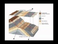
What is a block diagram used for in geology?
To measure the temperature of rocks.
To represent cross-sections of rock formations.
To show the color of rock layers.
To calculate the age of rocks.
5.
MULTIPLE CHOICE QUESTION
30 sec • 1 pt
How does erosion affect the appearance of rock layers on a geologic map?
It makes all layers appear thicker.
It has no effect on the appearance.
It affects the apparent thickness based on the angle of erosion.
It changes the color of the rock layers.
6.
MULTIPLE CHOICE QUESTION
30 sec • 1 pt
What do the symbols on a geologic map indicate?
The type and orientation of rock formations.
The temperature of the rocks.
The depth of the rock layers.
The age of the rocks.
7.
MULTIPLE CHOICE QUESTION
30 sec • 1 pt
How are anticlines and synclines represented on a geologic map?
With specific symbols and arrows.
With depth measurements.
With temperature readings.
With color codes.
Access all questions and much more by creating a free account
Create resources
Host any resource
Get auto-graded reports
Continue with Google

Continue with Email
Continue with Classlink
Continue with Clever
or continue with
Microsoft
%20(1).png)
Apple
Others
Already have an account?
Similar Resources on Wayground

2 questions
INTERVIEW - Miranda Lambert and Carrie Underwood - Billboard Music Awards 2014 - Rehearsals Day 2
Interactive video
•
9th - 10th Grade
2 questions
Hard Rock Cafe Opening in Cabo San Lucas
Interactive video
•
9th - 10th Grade
8 questions
CLEAN : Steven Appleby's August Crimp: the cross-dressing crusader
Interactive video
•
9th - 10th Grade
6 questions
CLEAN : Young Chicagoans rap and dance to memorialize Juice WRLD
Interactive video
•
9th - 10th Grade
6 questions
Igneous and Metamorphic Rocks: Contact Metamorphism
Interactive video
•
10th - 12th Grade
6 questions
Sedimentary Rocks: Clastic Sedimentary Rocks
Interactive video
•
10th - 12th Grade
2 questions
Angus Young and Brian Johnson
Interactive video
•
9th - 10th Grade
2 questions
CLEAN : Original Jesus Ted Neeley brings Superstar to Rome
Interactive video
•
9th - 10th Grade
Popular Resources on Wayground
8 questions
Spartan Way - Classroom Responsible
Quiz
•
9th - 12th Grade
15 questions
Fractions on a Number Line
Quiz
•
3rd Grade
14 questions
Boundaries & Healthy Relationships
Lesson
•
6th - 8th Grade
20 questions
Equivalent Fractions
Quiz
•
3rd Grade
3 questions
Integrity and Your Health
Lesson
•
6th - 8th Grade
25 questions
Multiplication Facts
Quiz
•
5th Grade
9 questions
FOREST Perception
Lesson
•
KG
20 questions
Main Idea and Details
Quiz
•
5th Grade