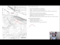
Understanding Drainage and Contour Lines
Interactive Video
•
Geography
•
9th - 10th Grade
•
Practice Problem
•
Hard

Patricia Brown
FREE Resource
Read more
10 questions
Show all answers
1.
MULTIPLE CHOICE QUESTION
30 sec • 1 pt
What is the primary function of a drainage basin?
To store water permanently
To prevent water from flowing
To direct water flow to a common outlet
To increase water evaporation
2.
MULTIPLE CHOICE QUESTION
30 sec • 1 pt
How can you identify a stream on a contour map?
By looking for convex shapes
By locating the flattest areas
By finding the highest points
By identifying concave V-shaped patterns
3.
MULTIPLE CHOICE QUESTION
30 sec • 1 pt
Why is it important to understand the spacing of contour lines?
It helps in identifying the type of vegetation
It marks the boundaries of properties
It indicates the steepness of the slope
It shows the depth of water bodies
4.
MULTIPLE CHOICE QUESTION
30 sec • 1 pt
What does a closely spaced contour line indicate?
A water body
A steep slope
A flat area
A valley
5.
MULTIPLE CHOICE QUESTION
30 sec • 1 pt
What is the first step in delineating a drainage basin?
Finding your point of interest
Drawing from hilltop to hilltop
Identifying the ridges and valleys
Ignoring all roads
6.
MULTIPLE CHOICE QUESTION
30 sec • 1 pt
How should flow paths be drawn in relation to contour lines?
Perpendicular to the contour lines
Randomly across the contour lines
At a 45-degree angle to the contour lines
Parallel to the contour lines
7.
MULTIPLE CHOICE QUESTION
30 sec • 1 pt
In residential areas, why are roads significant in drainage planning?
They are always the lowest points
They act as natural water barriers
They are typically crowned, directing water to inlets
They absorb water to prevent flooding
Access all questions and much more by creating a free account
Create resources
Host any resource
Get auto-graded reports
Continue with Google

Continue with Email
Continue with Classlink
Continue with Clever
or continue with
Microsoft
%20(1).png)
Apple
Others
Already have an account?
