Mapping the Indian Ocean Mysteries
Interactive Video
•
Geography
•
9th - 10th Grade
•
Practice Problem
•
Hard

Patricia Brown
FREE Resource
Read more
10 questions
Show all answers
1.
MULTIPLE CHOICE QUESTION
30 sec • 1 pt
What was one of the main purposes of mapping parts of Australia's Indian Ocean?
To discover new species of marine life
To establish new shipping routes
To solve the mystery of a missing flight
To find new fishing grounds
2.
MULTIPLE CHOICE QUESTION
30 sec • 1 pt
In what year did flight MH370 disappear?
2015
2014
2013
2012
3.
MULTIPLE CHOICE QUESTION
30 sec • 1 pt
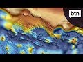
How much of the ocean was mapped during the search for MH370?
1.7 million square kilometers
4.7 million square kilometers
2.7 million square kilometers
3.7 million square kilometers
4.
MULTIPLE CHOICE QUESTION
30 sec • 1 pt
What is the 'fish' in the context of ocean mapping?
A type of sonar device
A satellite used for mapping
A nickname for an underwater vehicle
A new species discovered
5.
MULTIPLE CHOICE QUESTION
30 sec • 1 pt
What kind of information does the 'fish' collect?
Marine life populations
Ocean current patterns
Seafloor terrain details
Temperature and salinity levels
6.
MULTIPLE CHOICE QUESTION
30 sec • 1 pt
What was one of the surprising discoveries made during the mapping efforts?
A new island
A shipwreck over a hundred years old
A new species of fish
An underwater city
7.
MULTIPLE CHOICE QUESTION
30 sec • 1 pt
What geological feature was discovered that dates back 140 million years?
A deep trench
A coral reef
A volcanic island
A broken ridge
Access all questions and much more by creating a free account
Create resources
Host any resource
Get auto-graded reports
Continue with Google

Continue with Email
Continue with Classlink
Continue with Clever
or continue with
Microsoft
%20(1).png)
Apple
Others
Already have an account?
