Oceanographic Data Collection Methods
Interactive Video
•
Science
•
9th - 10th Grade
•
Practice Problem
•
Hard

Patricia Brown
FREE Resource
Read more
10 questions
Show all answers
1.
MULTIPLE CHOICE QUESTION
30 sec • 1 pt
What is one of the main advantages of using satellites for oceanographic studies?
They offer nearly continuous global coverage.
They provide detailed information about ocean depth.
They can measure the salinity of the ocean.
They are unaffected by atmospheric conditions.
2.
MULTIPLE CHOICE QUESTION
30 sec • 1 pt
What is a limitation of satellites in oceanographic research?
They are unable to transmit data in real-time.
They cannot provide any data about the ocean surface.
They only offer detailed information about small areas.
They do not provide information about what lies beneath the ocean surface.
3.
MULTIPLE CHOICE QUESTION
30 sec • 1 pt
How do moorings differ from satellites in terms of data collection?
Moorings are more expensive than satellites.
Moorings can only be used in shallow waters.
Moorings offer detailed temporal data at specific locations.
Moorings provide broad spatial coverage.
4.
MULTIPLE CHOICE QUESTION
30 sec • 1 pt
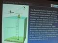
What is the primary function of the Bermuda test bed mooring?
To track ocean currents.
To provide global ocean coverage.
To measure atmospheric conditions.
To collect continuous time series data below the ocean surface.
5.
MULTIPLE CHOICE QUESTION
30 sec • 1 pt
What is an Argo float?
A ship-mounted sensor for spatial resolution.
A self-profiling robot that measures ocean properties.
A type of satellite used for oceanographic studies.
A fixed buoy used to measure atmospheric conditions.
6.
MULTIPLE CHOICE QUESTION
30 sec • 1 pt
How do Argo floats control their buoyancy?
By using a motor to pump oil in and out of a bladder.
By using external weights.
By adjusting their weight.
By changing their shape.
7.
MULTIPLE CHOICE QUESTION
30 sec • 1 pt
What is the significance of Argo floats in climate change studies?
They provide data on ocean currents.
They measure atmospheric temperatures.
They offer insights into ocean warming due to climate change.
They track the movement of marine life.
Access all questions and much more by creating a free account
Create resources
Host any resource
Get auto-graded reports
Continue with Google

Continue with Email
Continue with Microsoft
or continue with

%20(1).png)
Apple
Others
Already have an account?
